Sandy could rough up South Florida with high winds
- Submitted by: lena campos
- Intense rains and floods
- 10 / 24 / 2012
Tropical Storm Sandy might rough up South Florida Thursday and Friday with strong winds, possibly causing significant beach erosion, downing power lines and trees and triggering minor coastal flooding, the National Weather Service said.
While South Florida still remains clear of Sandy's cone of error, the projected path has been shifted west, putting the system's core about 200 miles east of Miami on Friday. As a result, the region could see winds gusting to 40 mph on Thursday and 50 mph on Friday.
"These winds would likely lead to downed trees and power lines with many power outages, as well as dangerous conditions for high-profile vehicles and on bridges and overpasses," said meteorologist Robert Molleda.
While Sandy's heaviest downpours should remain offshore, it still could produce 1 to 2 inches of rain Thursday through Saturday, Molleda said.
"If heavier rain bands expand farther west, then amounts could be at least twice of what I'm indicating," he said. "Right now flooding potential is on the low side, but we will have to monitor the system very closely."
The winds also have created a high risk of rip currents at the beaches through Friday afternoon, the weather service said.
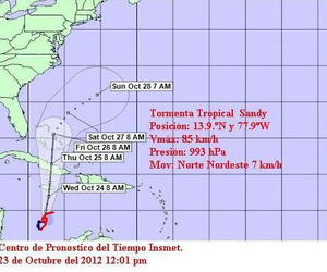
At 5 p.m. on Tuesday, Sandy was in the Caribbean about 260 miles southwest of Kingston, Jamaica, crawling north at 6 mph with sustained winds of 50 mph.
Central Florida also can expect to see windy conditions with gusts up to 50 mph on Thursday, Friday and Saturday, the result of high pressure to the north interacting with Sandy to the south.
It's too soon to say whether a tropical storm watch will be needed for South Florida, said Dennis Feltgen, spokesman for the National Hurricane Center.
"A watch would be issued if there is a possibility of tropical storm conditions within 48 hours," he said. "We have to wait and see how things go with the track during the next day or so."
Sandy likely will cause beach erosion along all of South Florida's shoreline, said Eric Myers, natural resources adminsitrator for the Broward County Environmental Protection and Growth Management Department.
The direction of the winds, their strength and their duration all will determine how severe the erosion will be, he said.
"There's nothing we can do at this point except grit our teeth and hope it remains as far away as possible," Myers said.
More immediately, Sandy is forecast to intensify into a hurricane and threaten Jamaica on Wednesday and Cuba on Thursday.
It is expected to produce up to 16 inches of rain along its path and possibly cause flooding in Jamaica, Cuba and Haiti.
A hurricane warning has been posted for Jamaica and the eastern half of Cuba, and a tropical storm warning has been issued for Haiti.
After crossing over Cuba on Thursday, is it is predicted to weaken back into a tropical storm and move through the central Bahamas. If that prediction holds, the core of the system would be about 200 miles east of South Florida on Friday.
After departing the Bahamas, Sandy is expected to curve northeast into the Atlantic and start falling apart by Sunday.
Meanwhile, Tropical Depression 19 is forecast to grow into Tropical Storm Tony by Wednesday in the Central Atlantic. It poses no immediate threat to land.
If the system does become the 19th named storm, 2012 would become the third busiest season on record, tied with 1887, 1995, 2010 and 2011.
The top two seasons on record: 1933 with 21 storms and 2005 with 28 storms.
Source: Sun-sentinel.com
Comments