Cuba’s Forecasters: Irene Moves West Towards PR, DR & Haiti
- Submitted by: manso
- Society
- 08 / 21 / 2011
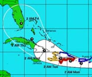
August 21, 2011. The projected path of Tropical Storm Irene as of 6 a.m. Sunday morning. Graph: INSMET
HAVANA TIMES, August 21 — Tropical Storm Irene continues to move west and in the next 24-30 hours is expected to move close to Puerto Rico and touch land somewhere on the south coast of the Dominican Republic possibly as a hurricane.
At 6:00 a.m. EDT, Irene was located by the Cuban Weather Service (INSMET) at 15 miles north-northwest of Guadalupe Island and 45 miles south-southeast of Antigua.
The storm packed 50 mph maximum sustained winds and a minimum pressure of 1006 millibars.
INSMET said TS Irene should gain in intensity and tip slightly to the west-northwest in the coming 24-48 hours as well as slow down in its movement currently at 21 mph.
After coming aground somewhere in the Dominican Republic and crossing over part of Haiti, the storm’s current projected path would take it towards the eastern Cuban province of Guantanamo.
This possibility has INSMET and Cuba’s Civil Defense authorities paying close attention to the development and course of Irene.
Source: www.havanatimes.org/?p=49138
Comments