New Tropical System Threatens Antilles
- Submitted by: manso
- Society
- 08 / 20 / 2011
By Alex Sosnowski, Expert Senior Meteorologist. Aug 20, 2011; 11:21 AM ET. An area of disturbed weather that may garner the name Irene will threaten the Antilles from the Windward Islands through Cuba with torrential rain and gusty winds.
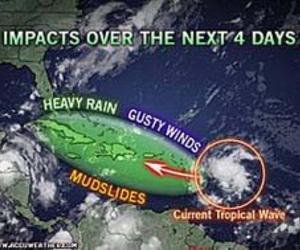
As of Saturday midday, the system is still in the developing and pre-tropical storm stage. However, even in its infancy, it brings the risk of flash flooding, mudslides and dangerous surf conditions to those usually tranquil island nations.
We don't want to get the cart before the horse, but at the very least this is one of several legitimate threats these islands experience during a typical hurricane season.
Interaction with the Antilles, especially the larger islands, may determine how quickly the system ramps up.
According to Hurricane and Tropical Weather Expert Dan Kottlowski, "There also continue to be issues with dry air being drawn into the system."
We have had eight tropical storms and no hurricanes so far this season.
Just days earlier, Gert set a record for rifling through the first seven named systems in the Atlantic without a hurricane, according to Meteorologist Cory Mottice.
Most recently, Harvey added to this record for the 2011 season, while forming near the coast of Central America. Harvey will move inland before becoming a hurricane, but will bring torrential rainfall and the risk of life-threatening flooding and mudslides as Meteorologist Matt Alto explains.
If the system overcomes the natural obstacles, we may not only have another tropical storm, but the season's first Atlantic hurricane.
Timing of Impacts
We want to stress that the timing of the system is highly dependent on the north-south orientation of the track, size, and strength of the system itself.
All tropical systems are unique, and this one is like an infant still developing its personality.
This system is likely bring locally gusty, heavy squalls to the Windward and Leeward islands Sunday, the Virgin Islands Sunday night and Monday, and Puerto Rico and Hispaniola Monday into Tuesday.
Jamaica is scheduled to be impacted Tuesday into Wednesday.
Next up would be Cuba Tuesday into Thursday.
For possible U.S. mainland impact, let's just say the second half of next week into next weekend is the time period on the table for now.
Source: /www.accuweather.com/blogs/news/story/54020/new-tropical-system-threatens.asp
Comments