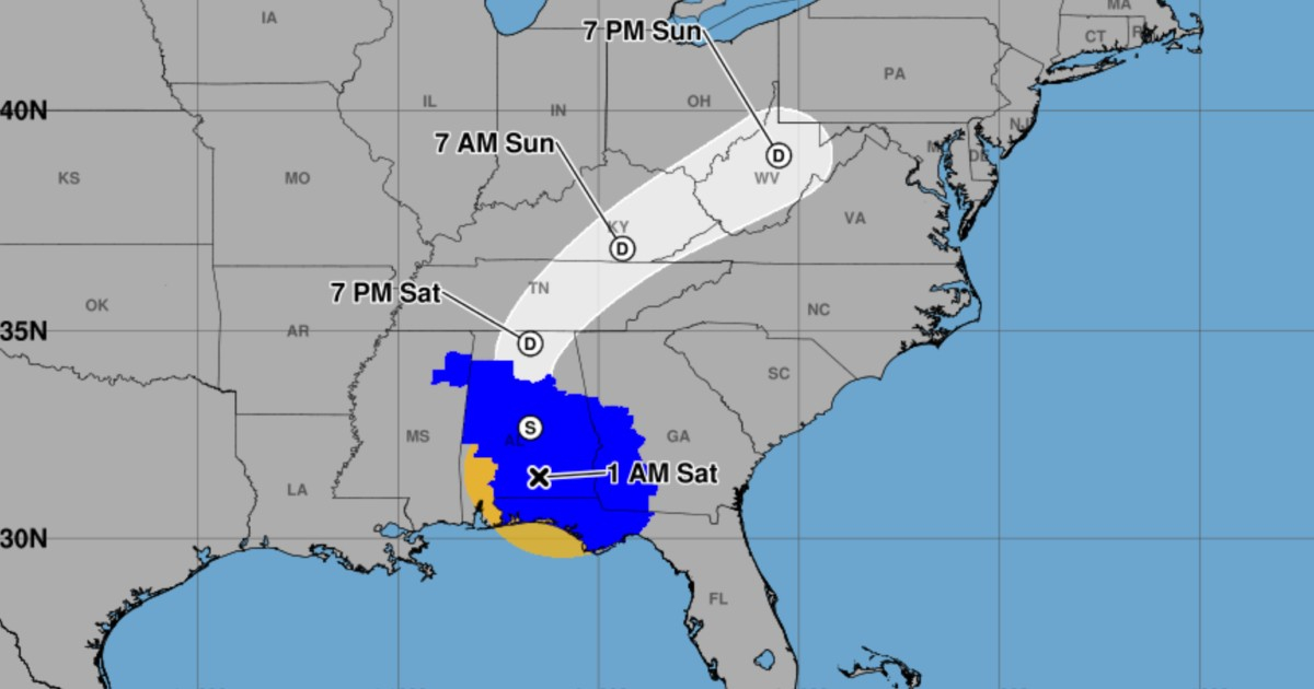
Isaias has now transformed into a post-tropical cyclone, yet it retains maximum sustained winds of 65 mph (100 km/h). The storm continues to pose a significant threat through heavy rains, potential flooding, and strong gusts across the southeastern United States, as confirmed by the National Hurricane Center (NHC).
The latest classification is detailed in the NHC's intermediate advisory 14A, effective as of 1:00 a.m. CDT on Saturday, October 10, 2026 (2:00 a.m. Miami time; 06:00 UTC). This marks a shift from the previous advisory, which still categorized Isaias as a hurricane and anticipated its transition to a post-tropical system.
At that time, Isaias was centered over southern Alabama, approximately 81 miles north-northeast of Pensacola, Florida, and 56 miles south-southwest of Montgomery, Alabama. It was moving northward at 19 mph, with a central pressure estimated at 1,000 millibars. Tropical storm-force winds extended outward up to 162 miles from the center.
Warnings Adjusted, But Alerts Persist in Florida
The NHC expects a gradual weakening as the system travels through Alabama and toward the Tennessee Valley over the weekend. However, strong gusts might continue to be felt inland even after the post-tropical transition.
Hurricane warnings have been lifted, but alerts remain in effect for Florida. The NHC has canceled the hurricane warning west of the Alabama-Florida border, replacing it with a tropical storm warning from east of that border to the Bay and Gulf County line in Florida. Additionally, the storm surge warning west of the Santa Rosa-Okaloosa county line has been withdrawn.
Nonetheless, a storm surge warning persists from the Santa Rosa-Okaloosa divide to the Suwannee River in Florida, alongside a tropical storm warning from east of the Alabama-Florida border to the Aucilla River.
Flood Threats, Tornado Risk, and Dangerous Surf
Forecasts predict rainfall amounts of 4 to 8 inches (100 to 200 millimeters) through the end of the weekend in southern Alabama, the Florida Panhandle, and the Big Bend region, as well as southwest Georgia. Localized heavy rain bands could result in accumulations up to 15 inches (380 millimeters), particularly in the Panhandle and Big Bend areas.
Elsewhere in the southeastern U.S., expected rainfall ranges from 2 to 5 inches, with locally higher amounts possible. The NHC warns of potential flash floods, urban inundations, river flooding, and landslides, especially in the southern Appalachians.
The bulletin also highlights a continued tornado risk throughout Saturday for parts of the Florida Panhandle, Georgia, and the Carolinas. Additionally, surf generated by Isaias is affecting parts of the U.S. and Mexican Gulf coasts, as well as western Cuba, posing a threat of dangerous rip currents.
This represents a new stage for the system after Isaias previously weakened to a Category 1 hurricane following landfall in Florida. The post-tropical designation indicates it is no longer classified as a tropical cyclone, though its hazardous effects remain.
Authorities urge residents in warning areas to heed evacuation and safety instructions from local services. The NHC scheduled its next full advisory for 4:00 a.m. CDT on Saturday, meaning updates and alerts could change. This article's information comes from intermediate advisory 14A, as of 06:00 UTC on October 10.
Key Information on Post-Tropical Cyclone Isaias
What is the current status of Isaias?
Isaias is now classified as a post-tropical cyclone with sustained winds of 65 mph. It continues to pose risks of heavy rain, flooding, and strong winds in the southeastern United States.
Where is Isaias currently located?
As of the latest advisory, Isaias was centered over southern Alabama, approximately 81 miles north-northeast of Pensacola, Florida.
What areas are under warning due to Isaias?
Tropical storm and storm surge warnings are in effect in parts of Florida, including from the Santa Rosa-Okaloosa county line to the Suwannee River.
What are the potential hazards associated with Isaias?
Isaias presents potential hazards such as heavy rainfall, flash flooding, tornadoes, and dangerous surf conditions, particularly in the southeastern U.S.