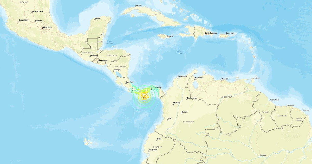
A significant earthquake with a magnitude of 7.6 jolted Panama on Friday, October 9, 2026, at 12:56 p.m. local time, as per the updated data from the United States Geological Survey (USGS). The tremor, centered near Pitaloza Arriba in Herrera province, raised concerns about a potential tsunami threat along the Pacific coastline.
The USGS pinpointed the epicenter approximately ten kilometers west-southwest of Pitaloza Arriba, at an estimated depth of 10 kilometers. Initially reported as an 8.0 magnitude quake, it was later revised to 7.6. The location and other seismic parameters are subject to further adjustments as more data becomes available.
The quake's impact was felt even in Panama City, where buildings swayed, prompting some residents to evacuate and gather in the streets. According to the Associated Press, evacuations took place as locals awaited updates on the quake's aftermath.
NOAA's Initial Tsunami Alert
Shortly after the quake, the Pacific Tsunami Warning Center (PTWC), a branch of the National Oceanic and Atmospheric Administration (NOAA), issued an initial alert regarding the potential for hazardous waves in specific Pacific coastal areas.
The first bulletin, released at 18:01 UTC (1:01 p.m. in Panama), assessed coastal areas of Panama, Costa Rica, Colombia, Ecuador, Peru, Nicaragua, El Salvador, Guatemala, and Mexico. It included estimated arrival times for a potential first wave at various Panamanian coastal points, including Punta Mala, Puerto Piña, Punta Burica, and Balboa Heights.
These times are projections of a possible scenario and do not confirm a tsunami's arrival. An initial warning does not imply that all mentioned countries have declared national alerts or evacuations. The threat level should be reassessed as specialized agencies receive sea level data.
The PTWC's message is directed at national authorities responsible for determining applicable measures within their territories. For the most current assessment, consult NOAA's updated bulletins and guidance from Panama's National Civil Protection System (Sinaproc). The first notice may be modified or canceled; it should not be automatically interpreted as a continuously active alert.
Initial Reports and Safety Advice
In its preliminary coverage, the Associated Press had not yet provided a comprehensive report on potential casualties or material damage. Images and accounts circulating on social media need verification before being attributed to this earthquake.
The threat outlined in the initial bulletin pertains to Pacific Ocean areas and should not be confused with warnings that have affected the Caribbean in other instances. For example, in February 2025, CiberCuba reported the cancellation of a Caribbean tsunami warning following a quake north of Honduras—an entirely different event.
Safety Measures for Coastal Residents
NOAA advises individuals near the sea who experience a strong or prolonged tremor to move away from the coast, seek higher ground, or head inland as soon as it is safe, rather than waiting for an official warning.
It is also recommended to stay away from beaches, ports, and river mouths, follow local authorities' instructions, and not return to evacuation areas until they give the all-clear. Tsunamis can arrive in multiple waves, and the first may not necessarily be the largest.
Frequently Asked Questions about the Panama Earthquake and Tsunami Warning
What was the magnitude of the earthquake in Panama?
The earthquake that struck Panama had a magnitude of 7.6, as updated by the United States Geological Survey (USGS).
Where was the epicenter of the earthquake?
The epicenter was located near Pitaloza Arriba in the province of Herrera, roughly ten kilometers west-southwest of the area.
What actions should be taken in case of a tsunami warning?
If you are in a coastal area and feel a strong or prolonged tremor, move away from the coast and seek higher ground or go inland immediately, following local authorities' instructions.