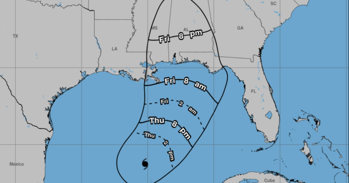
The United States' National Hurricane Center (NHC) announced on Thursday, October 8, an expansion of the storm surge warning in Florida, coinciding with Hurricane Isaias gaining strength with maximum sustained winds reaching 85 miles per hour (140 km/h).
According to the NHC's bulletin number 8, released at 10:00 a.m. CDT (11:00 a.m. in Miami), the storm surge warning now extends from the Steinhatchee River to the Suwannee River in Florida. This adjustment shifts the eastern boundary of the area under the threat of potentially deadly coastal flooding.
The NHC, in its official X message, indicated that Isaias had strengthened and urged the completion of preparations on Thursday to protect lives and property against the impending surge and damaging winds.
Expansion of Storm Surge Alert in Florida
The most significant update is the enlargement of the storm surge warning reaching the Big Bend area of Florida, from Steinhatchee to the Suwannee River. This segment adds to the warning that already covered much of the northern Gulf coast.
A storm surge warning implies a danger of potentially life-threatening flooding due to rising sea levels during the cyclone. It should not be confused with a hurricane warning, which pertains to hurricane-force winds.
For those residing in low-lying coastal communities, the water rise poses a danger even beyond the precise point where Isaias makes landfall. Local authorities might issue evacuation orders in vulnerable areas.
Isaias Intensifies with Sustained Winds of 140 km/h
The update in bulletin 8 increases the maximum sustained winds of Isaias from 80 miles per hour (130 km/h) reported in the previous advisory to 85 miles per hour (140 km/h). The cyclone remains a Category 1 hurricane on the Saffir-Simpson scale.
According to the reported data, the estimated minimum central pressure was 975 millibars, and the hurricane was moving east-northeast at approximately 10 miles per hour (17 km/h).
The NHC warned that Isaias might continue to intensify before approaching the northern Gulf coast. The projected path suggested the system would reach the coast between the night of Friday, October 9, and the early hours of Saturday, October 10.
Urgent Preparations for Surge and Winds
The NHC urged residents in areas under warning to finalize their preparations on Thursday. Those in flood-prone zones should adhere to local authorities' instructions, pay attention to evacuation orders, and avoid driving on flooded roads.
The threats associated with the cyclone include storm surge, destructive winds, heavy rainfall, and potential inland flooding. Conditions and areas under warning may change with subsequent forecast updates.
For the latest warnings, consult the National Hurricane Center and the Florida Division of Emergency Management.
This update is subsequent and distinct from CiberCuba's coverage of the initial storm surge warnings in the Gulf, Isaias' transition to a hurricane, and the elevation of alerts in Alabama and Mississippi interiors.
Editorial Note: The exact delineation and data from bulletin 8 should be verified with the full official text from the NHC before publishing; the advisory released on X confirms the strengthening and urgency of preparations but does not alone specify the new surge boundary.
Key Questions About Hurricane Isaias
What areas are under the expanded storm surge warning in Florida?
The storm surge warning has been extended from the Steinhatchee River to the Suwannee River in Florida, covering the Big Bend area.
What is the current strength of Hurricane Isaias?
Hurricane Isaias has reached maximum sustained winds of 85 mph (140 km/h), maintaining its status as a Category 1 hurricane.
How should residents in the affected areas prepare?
Residents should complete their preparations, follow local evacuation orders, and avoid traveling on flooded roads to ensure safety from the storm surge and high winds.