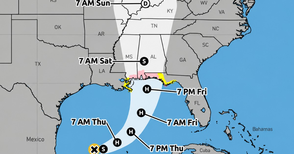
The tropical storm known as Isaiah is intensifying over the Gulf of Mexico and is expected to escalate into the first hurricane of the 2026 Atlantic season by Thursday. This development follows an extraordinarily quiet hurricane season that has already set records for its delayed start in producing a storm of hurricane strength.
On Wednesday, hurricane hunters from the United States' National Oceanic and Atmospheric Administration (NOAA) detected that the system was gaining power. According to the National Hurricane Center's (NHC) Intermediate Advisory 4A, released at 1:00 p.m. CDT, Isaiah had maximum sustained winds of 50 mph (85 km/h) and a central pressure of 997 millibars.
Earlier that day, at 10:00 a.m., the storm had winds of 45 mph with a pressure of 1,000 millibars. Overnight, it had recorded winds of only 40 mph and a pressure of 1,004 millibars, indicating a significant strengthening as it travels over the Gulf's warm waters.
Located approximately 410 kilometers west-northwest of Progreso, Mexico, and about 840 kilometers south-southwest of the Mississippi River's mouth, Isaiah was moving east-northeast at around eight miles per hour.
Strengthening Forecast for Isaiah
The NHC anticipates Isaiah becoming a hurricane on Thursday, with forecasts suggesting significant strengthening in the coming hours. The storm could reach winds of 75 mph, surpassing the hurricane classification threshold of 74 mph.
Should these predictions hold, Isaiah will be the first hurricane of the 2026 Atlantic season. Moreover, the NHC projects that the storm might attain winds of 90 mph on Thursday and up to 110 mph (175 km/h) on Friday while still over the Gulf. This upper limit would nearly classify it as a Category 3 hurricane on the Saffir-Simpson scale, just one mile per hour shy of that category. However, it is important to note that these are intensity forecasts and not certainties, as the storm's final strength will depend on its internal organization and atmospheric conditions encountered en route to land.
Unprecedented Season Without Hurricanes Until October
Isaiah's potential escalation is particularly noteworthy due to the unusual nature of the 2026 season. The eight preceding named storms—Arthur, Bertha, Cristobal, Dolly, Edouard, Fay, Gonzalo, and Hanna—failed to reach hurricane strength. The NHC's records for this season showed zero hurricanes and no major hurricanes until Isaiah's formation.
In September, CiberCuba reported that 2026 had already set a new record in the satellite era for the latest formation of the first Atlantic hurricane. On September 11, the season surpassed the previous record shared by the 2002 and 2013 seasons. Nearly a month later, the Atlantic still hasn't recorded its first hurricane.
NOAA had forecasted a less active season than usual, revising its predictions in August to between seven and 13 named storms, two to six hurricanes, and up to two major hurricanes, largely due to the influence of El Niño and increased wind shear over the Atlantic.
Rising Risk for the U.S. Gulf Coast
Isaiah's strengthening coincides with active hurricane, storm surge, and tropical storm watches along parts of the U.S. Gulf Coast. The hurricane watch extends from Bay St. Louis, Mississippi, to Indian Pass, Florida. The NHC also maintains a storm surge watch from the Mississippi mouth to Yankeetown, Florida.
Previously, CiberCuba reported the activation of these watches due to Isaiah's intensification, with estimates suggesting a storm surge of five to seven feet in some coastal areas. The NHC warns of a growing risk of life-threatening storm surge and damaging winds in parts of Florida's Panhandle, southern Alabama, and Mississippi.
Residents under these watches are urged to prepare for potential long-term power outages and to follow local authorities' guidance.
Florida Braces for Impact
Florida Governor Ron DeSantis has declared a state of emergency in 25 counties in the state's northern and northwestern regions in anticipation of the cyclone's effects. Miami-Dade, Broward, and Palm Beach are not currently included in this declaration, which focuses on the Panhandle and northern Florida.
In addition to wind and storm surge threats, rainfall poses a concern. The Weather Prediction Center (WPC) forecasts a moderate risk of excessive rainfall on Friday in southern Alabama and western Florida's Panhandle, where Isaiah might arrive as a hurricane.
Forecasts also predict possible flash floods, urban flooding, and isolated river overflows on Friday and the weekend. NOAA is also monitoring the risk of tornadoes associated with the system as its bands approach Florida and other southeastern states.
Isaiah's Lack of Threat to Cuba
Cuba's Institute of Meteorology has indicated that Isaiah poses no direct threat to the island. Attention is now focused on the northern U.S. Gulf Coast as meteorologists closely monitor how quickly Isaiah can intensify before making landfall.
Frequently Asked Questions About Hurricane Isaiah
What is the current status of Tropical Storm Isaiah?
As of the latest updates, Tropical Storm Isaiah is intensifying and is expected to become the first hurricane of the season by Thursday, with maximum sustained winds potentially reaching 75 mph.
Why is the 2026 hurricane season considered unusual?
The 2026 hurricane season is unusual due to its delayed start in producing hurricanes, setting a new record in the satellite era for the latest first hurricane formation in the Atlantic.
What areas are currently under hurricane watch due to Isaiah?
A hurricane watch is in effect from Bay St. Louis, Mississippi, to Indian Pass, Florida, alongside other storm-related watches for the U.S. Gulf Coast.