The tropical storm Isaias poses dangers that extend beyond its intense winds and storm surge. Official forecasts from the United States now caution about heavy rainfall, sudden flooding, and the likelihood of tornadoes as the system approaches Florida and the northern Gulf Coast.
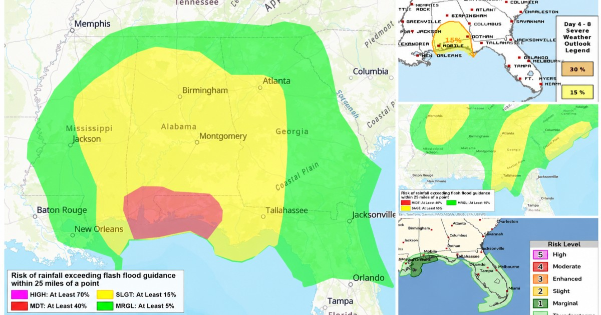
Renowned meteorologist Jim Cantore from The Weather Channel highlighted these additional threats on Wednesday through a post on social media, featuring official maps from the Storm Prediction Center (SPC) and the Weather Prediction Center (WPC), both part of the U.S. National Weather Service.
Cantore alerted the public that, besides the direct impacts of the storm, there's a potential for tornadoes and inland flooding on Friday and Saturday, with some risks potentially extending into Sunday depending on Isaias's progression.
Heightened Flooding Risks in Western Florida
The Weather Prediction Center (WPC) has identified a moderate risk of excessive rainfall for Friday in the southern tip of Alabama and the western Panhandle of Florida, marking it as the second-highest level on their four-tiered scale.
Official maps color this region in red, indicating at least a 40% chance that precipitation will exceed benchmark levels for flash floods within a 25-mile radius of any point.
A broader area, including other parts of Alabama, Georgia, and northern Florida, is also under a slight risk, correlating to a 15% chance based on the same criteria.
According to the WPC, Isaias, likely upgraded to a hurricane by then, is projected to near the Gulf Coast, make landfall, and move across the southeastern U.S. by Friday and Friday night.
Florida Prepares for Rain Even Before Isaias Arrives
Even before Isaias's core reaches the region, the WPC has maintained a marginal risk of excessive rainfall for much of Florida on Thursday.
The forecast suggests that a combination of tropical air masses, a stationary front, and slow-moving storms could result in localized heavy rain and sudden flooding.
By Thursday night, the initial outer bands of Isaias might start impacting the Apalachicola area and northwest Florida, gradually increasing the threat level.
Increased Tornado Potential with Storm's Approach
The maps shared by Cantore also include predictions from the Storm Prediction Center (SPC), which is monitoring an uptick in severe weather risks associated with Isaias.
The SPC anticipates that between Friday night and Saturday morning, storms capable of spawning tornadoes could emerge near the north-central Gulf Coast.
For Saturday, the multi-day forecast identifies a 15% risk of severe weather over parts of southern Alabama and the western Panhandle of Florida. This percentage should not be interpreted as a direct probability of tornado occurrence; the SPC's product encompasses various severe weather types.
The meteorological discussion highlights the potential for supercells capable of producing tornadoes, driven by strong wind shear east of the storm's center.
The exact location of these risks may shift if Isaias's projected path changes.
Isaias Poised for Rapid Intensification
The National Hurricane Center (NHC) reported on Wednesday that Isaias had maximum sustained winds of 40 mph (65 km/h) but anticipated rapid strengthening over the next two days.
The system is expected to become a hurricane by Thursday as it moves through Gulf waters toward the U.S. coast.
Earlier, news outlets reported that Isaias became a tropical storm in the Gulf of Mexico on Wednesday and could be the first hurricane of the 2026 Atlantic season.
Florida Governor Ron DeSantis had already declared a state of emergency in 25 counties, primarily in the northern and northwestern parts of the state, due to the storm's threat.
Continuing Threat Post-Landfall
New forecasts indicate that the risks associated with Isaias may persist even after the storm's center crosses onto land.
Heavy rain and potential flooding could spread inland across the southeastern U.S. throughout Saturday, potentially affecting areas in Alabama, Georgia, and nearby states.
Cantore urged residents to take advantage of the time available to finalize preparations and to heed local authorities' instructions if evacuation orders are issued.
The specific areas at greatest risk could change in the coming hours, so the NHC, WPC, and SPC recommend staying updated with official advisories as Isaias strengthens and its path toward the northern Gulf Coast becomes clearer.
Understanding the Threats Posed by Isaias
What additional dangers does Isaias pose besides strong winds?
Apart from strong winds, Isaias brings the threat of heavy rainfall, flash flooding, and potential tornadoes as it approaches Florida and the northern Gulf Coast.
How is Florida preparing for Isaias?
Florida has been placed under a state of emergency in 25 counties, with preparations underway for possible evacuation and safety measures as Isaias nears.
What is the likelihood of tornadoes with Isaias?
The Storm Prediction Center has noted a potential for tornadoes, particularly with supercells, due to strong wind shear east of Isaias's center during its approach.