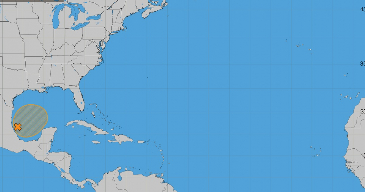
The United States' National Hurricane Center (NHC) has issued a monitoring bulletin early this morning regarding a tropical disturbance in the southwestern Gulf of Mexico. The system has a 50% chance of developing over the next week.
This system, referred to as "Disturbance 1," is described as a "surface trough of low pressure" situated along Mexico's southwestern Gulf coastline. Although environmental conditions are only marginally conducive, the NHC suggests a tropical depression might develop by midweek.
Potential Development and Path of the Disturbance
The NHC anticipates the system will initially move eastward before turning northward, a path that will be closely monitored in the coming days. While there is no immediate cyclonic threat, the likelihood of development increases as the week progresses.
The "48-hour formation probability" is a mere 10%, considered low, whereas the "7-day formation probability" rises to 50%, classified as moderate. As of now, no tropical depression has formed, and therefore, no official trajectory cone is available. Further updates will be necessary to determine any potential impacts on Cuba or Florida.
Uncertainty and Meteorological Analysis
Meteorologist Bryan Norcross from Fox Weather analyzed the system on Sunday, highlighting significant uncertainty. The models provide an unclear picture of the system's development and trajectory, compounded by "extremely hostile" high-level winds over the northern Gulf that could hinder organization.
Norcross speculated that the system is more likely to become a broad area of rain and storms affecting the Gulf and Florida rather than developing into a significant tropical system.
Florida Prepares for Heavy Rainfall
Regardless of whether the disturbance evolves into a tropical depression, Florida is already experiencing heavy rainfall, particularly in the northern and northwestern parts of the state. The National Weather Service (NWS) has forecast widespread accumulations of three to six inches in parts of the Florida Panhandle, with localized amounts between eight and ten inches.
Meteorologist Matt Devitt estimates that Florida could receive around 4.6 trillion gallons of rainwater over the next seven days. Flood alerts remain in effect for much of the region as the state braces for this substantial precipitation.
Exceptionally Quiet Hurricane Season
This disturbance is noteworthy amid an unusually calm Atlantic hurricane season. The NHC's update as of October 4, 2026, reports eight named storms, none reaching hurricane strength. The named storms include Arthur, Bertha, Cristobal, Dolly, Edouard, Fay, Gonzalo, and Hanna, all peaking as tropical storms.
This quiet is unusual: the 1991-2020 climatological average by this point is roughly 11 named storms, five hurricanes, and two major hurricanes. The Accumulated Cyclonic Energy (ACE) for 2026 is 89% below normal as of October 4.
Matt Devitt pointed out that the last time the Atlantic season reached this point without a hurricane was during World War I, in 1914. One factor contributing to this low activity is El Niño, which increases vertical wind shear over the Atlantic, typically hindering storm formation and intensification.
October's Historical Significance for Cuba
Despite a low-activity season, the threat remains. The Atlantic hurricane season officially lasts until November 30, with October historically significant for Cuba. A study in the Cuban Meteorology Journal found that October accounts for 35.5% of hurricanes affecting Cuba, ahead of September and August.
Recent years have demonstrated the risks cyclones pose during this period. In October 2024, Oscar brought torrential rains and dangerous flash floods to eastern Cuba. A year later, Melissa made landfall in eastern Cuba on October 29, 2025, as a Category 3 hurricane, causing severe flooding and landslides.
Current Challenges in Cuba Amid Monitoring
The monitoring of this disturbance occurs as Cuba faces a severe energy crisis. Analysis of the National Electroenergetic System's daily reports indicates that 23 out of 28 days from September 3 to October 2 exceeded 2,000 MW of maximum real impact.
In addition to electricity issues, essential services like water supply and meteorological monitoring are problematic. In early September, Cuban meteorologist Yosmelvi Páez reported that the country's eight meteorological radars were offline, and the public couldn't access radar images on the INSMET website.
This disturbance serves as a reminder that even a remarkably calm season can still pose threats in its final stretch. Official figures suggest caution, as development potential remains low at 10% over the next 48 hours, but rises to 50% over a week.
The key question is whether conditions will allow for "gradual development" as the NHC anticipates, potentially resulting in a tropical depression by midweek. Matt Devitt's inquiry from weeks ago remains relevant: "Will we end the season without a hurricane? Let's keep the streak going as long as we can."
Key Questions About Gulf Disturbance and Hurricane Season
What is the current likelihood of the disturbance developing into a tropical depression?
The National Hurricane Center estimates a 10% chance of development in the next 48 hours, increasing to 50% over the next seven days.
How is Florida preparing for the expected heavy rainfall?
The National Weather Service has issued flood alerts and forecasts widespread rain accumulations in the Florida Panhandle, with localized totals of up to ten inches.
Why has this hurricane season been unusually quiet?
The presence of El Niño has increased vertical wind shear in the Atlantic, which generally suppresses the formation and strengthening of tropical storms.