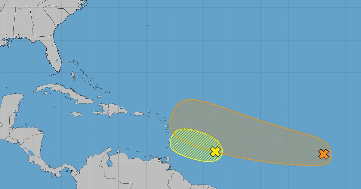
The potential danger posed by tropical system AL92 transforming into a cyclone as it approached the Caribbean has significantly decreased this Friday. The associated rain and storms began losing organization in the Atlantic, reducing the likelihood that the system will approach Cuba with any substantial intensity or organization.
The United States National Hurricane Center (NHC) reported in its latest update that AL92 is moving into an area with stronger upper-level winds and dry air, two factors that are hindering its development.
The chances of AL92 forming into a cyclone have dropped to 20% over the next 48 hours and the upcoming week, a clear indication that conditions are becoming increasingly unfavorable for its organization.
The Current Position and Impact of AL92
According to the NHC's 8:00 a.m. outlook, the tropical wave was located approximately 400 miles east of the Windward Islands, generating wind gusts and a broad area of showers and thunderstorms.
Meteorologists summarized in a post on the NHC’s official X account that development prospects are rapidly diminishing as the system encounters more hostile conditions.
Potential Effects on the Caribbean
This reduction in strength lowers the risk of AL92 significantly intensifying before approaching the Caribbean, although it's still too soon to completely rule out its impact on the region.
Even if it doesn't develop into a tropical storm, the system could still cause heavy rainfall and wind gusts in parts of the Lesser Antilles between Friday night and Saturday.
The marine forecast indicates that these conditions will progress towards the central Caribbean and the Greater Antilles, including the Windward Passage, from Saturday night through Monday. The system might weaken further as it continues westward across the Caribbean.
Outlook for Cuba
For Cuba, the situation is now less concerning than in previous days due to the significant decrease in cyclone development potential.
However, it's crucial to keep monitoring the wave's path, particularly for potential rain and winds, even if it never develops into a tropical cyclone.
While AL92 loses its structure, another system, identified as AL94, remains over the central tropical Atlantic.
Monitoring AL94
This system has a 30% chance of development over the next 48 hours and a 50% probability in the following seven days, making it the next system to watch closely in the Atlantic basin.
The NHC suggests that conditions around AL94 could support gradual development and does not rule out the possibility of a tropical depression forming over the weekend or early next week as it moves west or west-northwest.
Frequently Asked Questions About Tropical Systems in the Atlantic
What factors are hindering the development of AL92?
The development of AL92 is being hindered by stronger upper-level winds and dry air, which make the conditions less favorable for cyclone formation.
Could AL92 still impact the Caribbean?
Yes, even if it doesn't develop into a tropical storm, AL92 could still bring heavy rain and wind gusts to parts of the Lesser Antilles.
What is the forecast for the newly identified system AL94?
AL94 has a 30% chance of developing in the next 48 hours and 50% over the next seven days. It could become a tropical depression as it moves west or west-northwest.