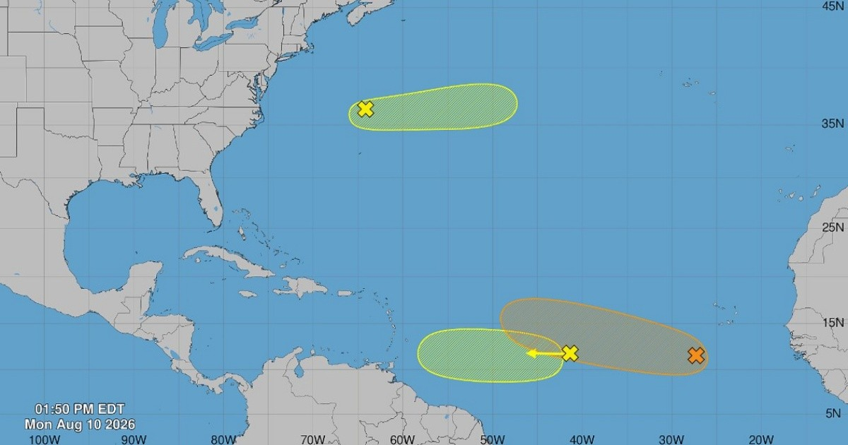
This Monday, the National Hurricane Center (NHC) raised the odds of the most active tropical system in the Atlantic forming into a tropical depression to 60% for the latter part of this week, according to the tropical outlook bulletin released at 2:00 p.m. Eastern Time.
This increase marks a steady rise: on Sunday morning, the probability was at 40%, climbing to 50% by afternoon, and reaching 60% on Monday. Just on Saturday, it was barely 30%.
The system is expected to evolve into a tropical depression by midweek as it moves toward the Caribbean.
Key System: Low Pressure Southwest of Cape Verde
The primary area of concern is a low-pressure zone situated several hundred miles southwest of the Cape Verde Islands, which is currently causing disorganized showers and thunderstorms as it slowly heads westward.
The NHC forecasts that a tropical wave about to emerge off the western coast of Africa will merge with this low-pressure area in a couple of days, enhancing conditions for its development.
The agency, based in Miami, stated: "Environmental conditions are expected to become more conducive for development by midweek, and a tropical depression could form during the latter half of this week as the system moves west to west-northwest across the central tropical Atlantic."
While the chance of formation in the next 48 hours remains low at 20%, the seven-day outlook, with its 60% probability, is attracting the attention of specialists.
Monitoring Additional Systems
Besides the main system, the NHC is also keeping an eye on two other disturbances with lower potential.
The second involves disorganized showers linked to a tropical wave located approximately midway between West Africa and the Lesser Antilles, carrying a 10% chance of formation within both 48 hours and seven days.
The NHC warned that "upper-level winds are expected to become less conducive for development later in the week as the system approaches the Lesser Antilles."
The third disturbance is a trough of low pressure north of Bermuda, also with a 10% probability in both time frames, whose chances of organization are expected to diminish after Wednesday as it moves into cooler waters.
Potential Paths and Impacts
As of now, there is no clear path toward the Caribbean or any confirmed threat to Cuba or other islands.
The National Weather Service in San Juan indicated on Sunday that models placed the wave's route northwest of Puerto Rico, without ruling out the possibility of bringing moisture and some rain to the island.
The system is predicted to move west or west-northwest across the central tropical Atlantic, a path that could eventually bring it near the Antilles.
Quiet Season, but Peak Activity Approaches
This activity is taking place during an exceptionally quiet 2026 hurricane season, with only two named storms—Arthur and Bertha—and neither reaching hurricane strength.
The main factor is El Niño, which increases vertical wind shear over the Atlantic, making it harder for cyclones to organize.
The NOAA updated its seasonal forecast on August 7, maintaining an expectation for between seven and 13 named storms, with a 75% chance that the season will be below average.
Nevertheless, the NHC has cautioned that "August typically marks an increase in cyclonic activity," with the climatological peak of the Atlantic season occurring around September 10.
For Cuba, the Institute of Meteorology (INSMET) estimated in May 2026 a 40% chance of at least one hurricane affecting the island during the season and a 75% likelihood of at least one tropical storm impacting it, amid a context of high vulnerability marked by power outages, food shortages, and water crisis.
Understanding Tropical Storm Development
What factors contribute to the development of tropical storms in the Atlantic?
Several factors can contribute to the formation of tropical storms, including warm sea surface temperatures, low wind shear, and sufficient moisture in the atmosphere.
How does El Niño affect hurricane activity in the Atlantic?
El Niño typically increases wind shear over the Atlantic, which can inhibit the development of hurricanes by disrupting the storm's structure.
When is the peak of the Atlantic hurricane season?
The peak of the Atlantic hurricane season occurs around September 10, when the ocean temperatures are warmest, providing favorable conditions for storm development.