Hurricane Melissa, which weakened to a Category 4 after crossing Jamaica on Tuesday, remains a highly intense cyclone as it moves towards eastern Cuba. The storm is already causing heavy seas with waves expected to soar up to 8 meters high by early Wednesday morning.
The Cuban Institute of Meteorology's Forecast Center (INSMET) released Tropical Cyclone Warning No. 20 at 6:00 p.m., stating that after moving over Jamaica, the hurricane's interaction with land caused "a slight weakening of its intensity," reducing it to Category 4 on the Saffir-Simpson scale.
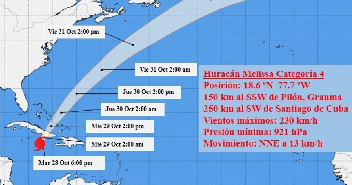
Despite this, Melissa still boasts maximum winds of 230 kilometers per hour, with even higher gusts, and its central pressure has increased to 921 hectoPascal. Therefore, it remains a very intense and extremely dangerous hurricane for Cuba, which lies in its path.
In the southern seas of Granma, Santiago de Cuba, and Guantánamo provinces, strong swells are being recorded, with waves ranging from 4 to 6 meters. These conditions are expected to persist for the next several hours, but by early Wednesday morning, waves could reach up to 8 meters, causing moderate to severe flooding in low-lying coastal areas, warned INSMET.
Meanwhile, tropical storm-force winds will intensify in the eastern region from the early evening, with speeds between 70 and 95 kilometers per hour, accompanied by higher gusts.
The hurricane's outer bands are impacting eastern Cuba with showers and rain, which will gradually increase as the storm approaches and passes through the area. Rainfall will be heavy and intense in some locations, particularly in mountainous regions, accumulating between 200 and 450 millimeters.
The meteorological phenomenon continues to move north-northeast at a speed of 13 km/h. At 6 p.m., Hurricane Melissa's center was estimated at 18.6 degrees North latitude and 77.7 degrees West longitude, placing it approximately 150 kilometers south-southwest of Pilón in Granma province and 250 kilometers southwest of Santiago de Cuba city.
In the next 12 to 24 hours, Melissa is expected to adjust its path more to the northeast and gradually increase its speed.
The powerful hurricane is "approaching the southern coast of eastern Cuba tonight, entering the territory somewhere between Granma and Santiago de Cuba." Although it "will experience fluctuations in intensity," according to INSMET, it will maintain its status as a major hurricane as it passes through Cuba.
The Cuban Institute of Meteorology's Forecast Center is closely monitoring the development and future trajectory of this intense hurricane and will issue another update on the tropical system at 9:00 p.m. Tuesday.
Renowned Cuban meteorologist José Rubiera issued an urgent alert ahead of Melissa's imminent arrival in eastern Cuba, warning that the storm "will be destructive," and residents in the region should protect their lives and those of their families from the extreme danger.
In a broadcast from his YouTube channel, the expert emphasized that the powerful cyclone will impact the eastern region between Tuesday night and Wednesday morning, with hurricane-force winds felt from Camagüey to Guantánamo. He stressed the need for timely evacuations and urged people not to stay in fragile homes or near the coast.
"Life cannot be replaced. A house can be rebuilt, but without life, nothing is resolved," he underscored.
According to the United States National Hurricane Center (NHC), Melissa will strike southeastern Cuba tonight, generating swells between 8 and 12 feet (2.5 to 3.5 meters) and rainfall accumulations of up to 25 inches (over 600 millimeters) in mountainous areas of eastern Cuba, potentially leading to catastrophic flooding and landslides.
The NHC cautioned that "very dangerous hours lie ahead," and the population should remain in safe places until authorities indicate otherwise.
Melissa has already made history by ranking among the most powerful hurricanes recorded in the Atlantic. With sustained winds of 295 km/h (185 mph), with higher gusts, and a minimum central pressure of 892 millibars (hectoPascals), the storm has joined the exclusive group of extreme Category 5 hurricanes, which includes historic "monsters" like Wilma (2005), Dorian (2019), and the Labor Day hurricane (1935).
Key Concerns About Hurricane Melissa's Impact on Cuba
How intense is Hurricane Melissa?
Despite weakening to a Category 4, Hurricane Melissa remains highly intense with maximum winds of 230 km/h, posing a significant threat to Cuba.
What areas of Cuba will be most affected?
Eastern provinces such as Granma, Santiago de Cuba, and Guantánamo are expected to experience the most severe effects, including strong waves and heavy rainfall.
What precautions should residents take?
Residents should evacuate fragile homes, avoid coastal areas, and stay in safe shelters until the authorities declare it secure to leave.