On Tuesday afternoon, Hurricane Melissa emerged off the northern coast of western Jamaica and is now moving toward eastern Cuba with maximum sustained winds of 145 mph (230 km/h), classifying it as a Category 4 storm on the Saffir-Simpson scale.
As of 5:00 pm EDT, the National Hurricane Center (NHC) reported that the eye of Melissa was positioned at 18.5°N, 77.7°W, approximately 12 miles east of Montego Bay and 202 miles southwest of Guantánamo. The storm has a central pressure of 921 mb and is moving north-northeast (25°) at 8 mph.
The NHC warned of destructive winds, catastrophic flash flooding, and life-threatening storm surges continuing in Jamaica as the evening progressed.
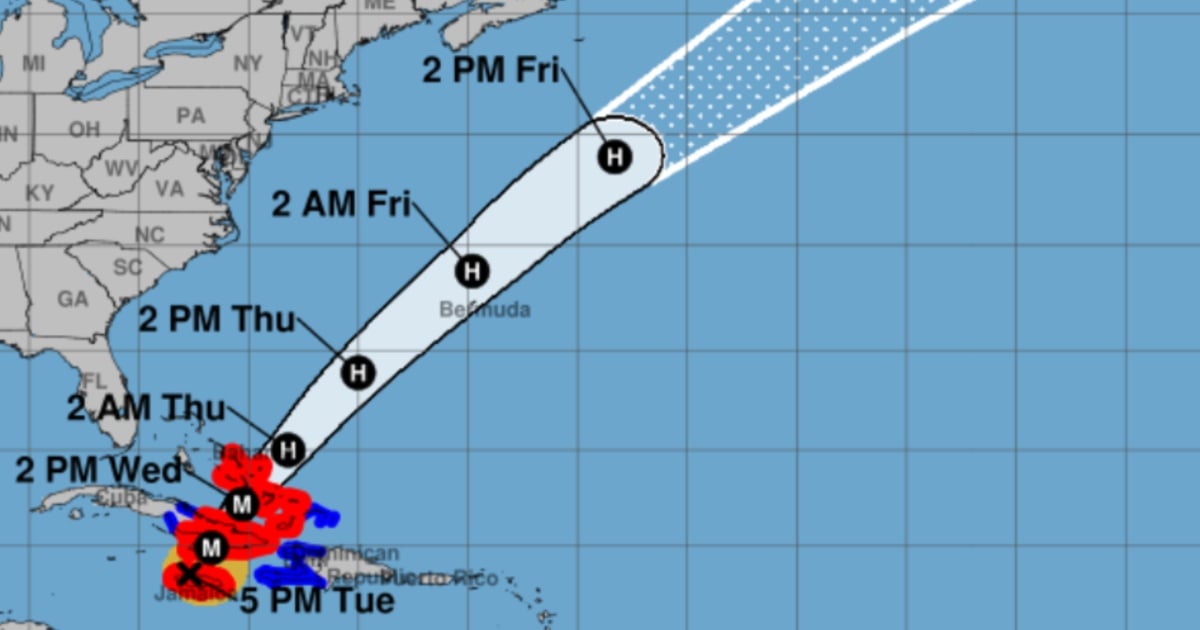
Projected Path and Impact
The official forecast suggests that Melissa's core will move away from western Jamaica tonight, with the center set to pass over southeastern Cuba between tonight and early Wednesday morning.
Following this, the storm is expected to cross the southeastern or central Bahamas on Wednesday and approach Bermuda by Thursday evening, shifting northeast and picking up speed midweek.
Even though intensity fluctuations are possible, the NHC anticipates Melissa will hit southeastern Cuba as an extremely dangerous major hurricane and could remain a hurricane while traversing the Bahamas.
Warnings and Precautions
The storm's vast wind field highlights its magnitude: hurricane-force winds extend up to 28 miles from the center, while tropical-storm-force winds reach 196 miles.
The NHC continues to enforce a hurricane warning for Jamaica, the Cuban provinces of Granma, Santiago de Cuba, Guantánamo, Holguín, and Las Tunas, as well as for southeastern and central Bahamas. A tropical storm warning remains for Haiti, Camagüey, and Turks and Caicos, while a hurricane alert is in place for Bermuda.
Residents in warning zones are urged to seek or remain in secure shelter immediately. In the Bahamas, preparations to protect lives and property should be finalized as soon as possible.
Rainfall and Flooding Risks
The threat of heavy rainfall is extreme. Jamaica expects an additional 6–12 inches, with total accumulations of 12–24 inches and isolated peaks nearing 30 inches in mountainous regions, exacerbating catastrophic flash floods and numerous landslides through Tuesday night.
In eastern Cuba, forecast totals range from 10–20 inches with local maximums of 25 inches, enough to cause life-threatening flash floods and multiple landslides.
The southern part of Hispaniola could see an additional 2–6 inches, with total storm accumulations reaching 40 inches in isolated areas. Southeastern Bahamas can expect 5–10 inches, and Turks and Caicos 1–3 inches, with areas experiencing rapid flooding.
Storm Surge and Coastal Impact
The NHC indicates that in northwestern Jamaica, near Montego Bay, storm surges could elevate 2–4 feet above ground level, while southern coastal flooding should subside tonight.
For southeastern Cuba, there is a significant potential for 8–12 feet above normal tide levels late today or Wednesday, near and east of the landfall point, accompanied by large, destructive waves. Minor coastal flooding is also possible in bays and inlets along Cuba's northeastern coast.
In the southeastern Bahamas, surges may reach 5–8 feet, and in Turks and Caicos, 2–4 feet.
Dangerous waves and rip currents will continue to affect Hispaniola, Jamaica, eastern Cuba, and the Cayman Islands, later spreading to the Bahamas, Turks and Caicos, and Bermuda.
Frequently Asked Questions About Hurricane Melissa
What category is Hurricane Melissa?
Hurricane Melissa is currently a Category 4 storm on the Saffir-Simpson scale, with maximum sustained winds of 145 mph (230 km/h).
What areas are under a hurricane warning due to Melissa?
Hurricane warnings are in effect for Jamaica, the Cuban provinces of Granma, Santiago de Cuba, Guantánamo, Holguín, and Las Tunas, as well as southeastern and central Bahamas.
What precautions should residents in affected areas take?
Residents should seek or remain in safe shelters immediately and complete all preparations to safeguard lives and property, especially in the Bahamas.