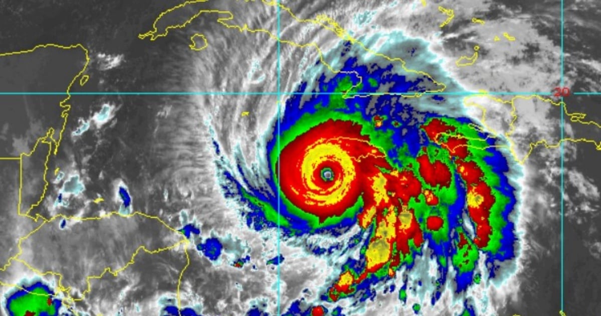
Hurricane Melissa, maintaining its status as a Category 5 storm—the highest level on the Saffir-Simpson scale—has slightly increased its speed and altered its course over the past three hours.
According to the latest advisory from the National Hurricane Center (NHC), Melissa is sustaining winds of 175 mph (280 km/h).
At 5:00 a.m. EDT on Tuesday, the central pressure was recorded at 901 mb, indicating the extreme intensity of this system.
Comparing it to the 2:00 a.m. bulletin, Melissa has adjusted its path slightly, now moving north-northeast (25 degrees) instead of north-northwest as previously reported.
This change in trajectory brings the hurricane closer to Jamaica, now positioned just 115 miles (180 km) from Kingston—20 miles nearer than in the earlier report.
Additionally, this powerful meteorological event has begun to pick up speed, albeit gradually.
Throughout the night, its forward speed doubled from 2 mph (3.22 km/h) to 5 mph (8.05 km/h), suggesting the system is entering a more dynamic movement phase, anticipated to pass over Jamaica today and eastern Cuba by early morning.
Impending Catastrophe for Jamaica: Immediate Impact Expected
In the early hours, the NHC warned, "Melissa is expected to make landfall as an extremely dangerous hurricane over Jamaica."
Melissa is already impacting Jamaica with tropical storm-force winds.
Kingston's airport reported sustained winds of 39 mph (63 km/h) with gusts reaching 58 mph (93 km/h), while Montego Bay experienced gusts of 57 mph (91 km/h).
However, these figures are merely the precursor to the main event.
The NHC cautions that hurricane-force winds are anticipated to commence this morning. In elevated or mountainous areas, gusts could be 30% stronger, potentially causing "complete structural failure" in vulnerable buildings, especially in windward regions.
Storm Surge and Rainfall Threats
The southern coasts of Jamaica are expected to endure a storm surge of 9 to 13 feet (up to 4 meters) above ground level, accompanied by destructive waves. On the northwest coast, including Montego Bay, the sea could rise between 2 and 4 feet.
Rainfall predictions are alarming. The NHC foresees 15 to 30 inches (38 to 76 cm) of rain on the island, with local maximums reaching 40 inches (over a meter). This could result in catastrophic flash flooding and massive landslides in both urban and rural areas.
Maximal Alert for Cuba: Eastern Provinces on High Alert
Eastern Cuban provinces, including Granma, Santiago de Cuba, Guantánamo, and Holguín, are under hurricane warnings.
Las Tunas is under a tropical storm warning.
The NHC urges completing preparations to protect lives and property in Cuba before conditions deteriorate tonight.
Rainfall expectations in eastern Cuba range from 10 to 20 inches, with maximums of up to 25 inches in specific areas. These downpours will likely be accompanied by life-threatening flash floods and landslides.
The southeastern Cuban coastline could experience a storm surge of up to 11 feet (3.3 meters) above normal levels, especially east of the hurricane's eye. The combination with powerful waves heightens coastal risks.
Regional Impact: Bahamas, Haiti, and Potentially Bermuda
In Haiti, already under a tropical storm warning, rain and flooding are expected from today through tomorrow.
Hurricane conditions are predicted for the southeastern and central Bahamas starting Wednesday, with rainfall between 5 and 10 inches and potential surges of 4 to 6 feet.
For the first time, the 5:00 a.m. bulletin includes a direct advisory for Bermuda.
An official watch has not yet been issued, but the NHC warns it may be necessary later today or tonight, depending on the storm's trajectory.
Extreme Marine Conditions: Waves and Rip Currents Across the Western Caribbean
Swells generated by Melissa are already affecting Hispaniola, Jamaica, eastern Cuba, and the Cayman Islands and will extend to the Bahamas, Turks and Caicos, and Bermuda in the coming days.
These waves and rip currents could be potentially deadly, the NHC advises.
The agency recommends that people avoid coastal areas and stay informed through official sources, as the system's evolution remains active and dynamic.
In summary, Melissa poses one of the most severe cyclonic threats in the Caribbean region in recent years.
Its combination of extreme winds, historic rainfall, direct trajectory over densely populated islands, and increasing forward speed make it a phenomenon of exceptionally high risk.
The international community and regional meteorological services are maintaining constant vigilance, while local authorities in Jamaica, Cuba, Haiti, and the Bahamas implement emergency plans, evacuations, and public service shutdowns.
Key Questions About Hurricane Melissa's Impact
What is the current status of Hurricane Melissa?
Hurricane Melissa is a Category 5 storm with sustained winds of 175 mph, showing a slightly increased speed and altered course toward the north-northeast.
What precautions should residents of Jamaica take?
Residents should prepare for extremely dangerous conditions, including hurricane-force winds, storm surges, and significant rainfall, and follow local authorities' evacuation and safety guidelines.
How might Hurricane Melissa impact Cuba?
Cuba's eastern provinces are under hurricane warnings, with expectations of heavy rain, storm surges, and the possibility of flash floods and landslides.