On Monday morning, a storm chaser's probe documented a staggering wind gust of nearly 250 mph—among the highest ever recorded by meteorologists—within the eye of Hurricane Melissa.
During a reconnaissance mission by a National Oceanic and Atmospheric Administration (NOAA) aircraft, a probe captured at 8:55 a.m. EDT (Eastern Daylight Time) a wind speed of 241 mph at an altitude of 709 feet. This measurement underscores the formidable strength of Hurricane Melissa, which has intensified to a Category 5, the highest on the Saffir-Simpson scale, marking it as one of the most powerful hurricanes to hit the Caribbean in decades.
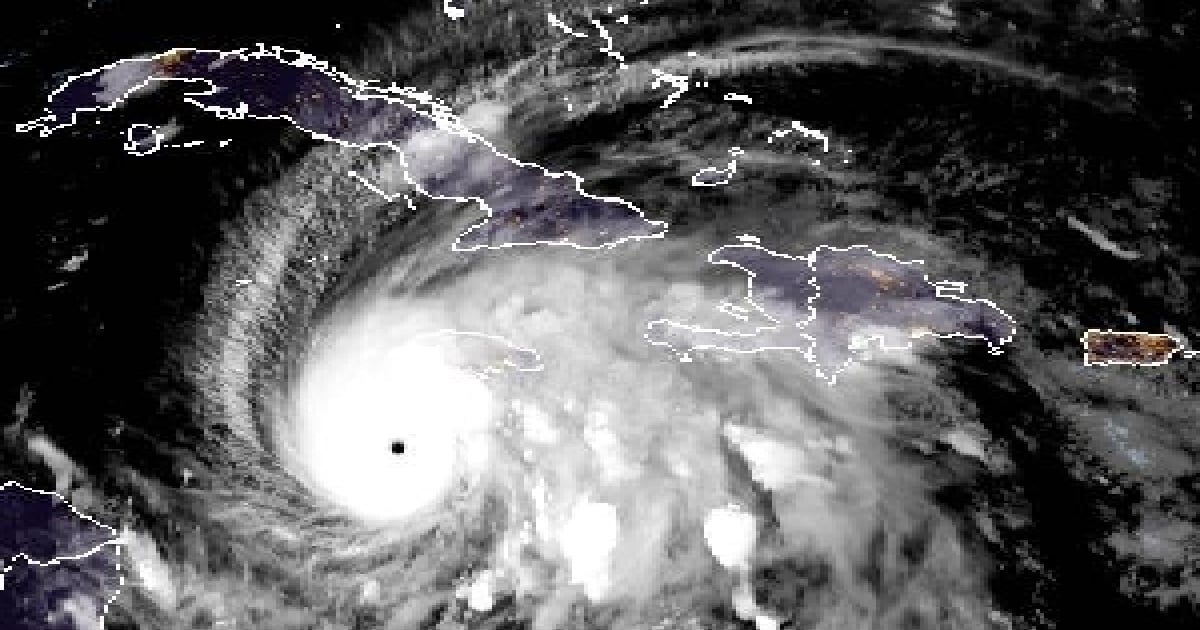
By 2 p.m. on Monday, Melissa had achieved sustained winds of 174 mph, with even higher gusts, and a central pressure of 906 mb (millibars), signaling a potentially catastrophic impact on Jamaica and Cuba.
After penetrating Melissa's eye twice, the NOAA hurricane hunter plane N42RF (Kermit) had to abort its mission due to severe turbulence in the southwest wall of the eye, reported meteorologist Jeff Masters in an article for Yale Climate Connections, a climate news service.
"This is only the fifth time I'm aware that NOAA's Hurricane Hunters have had to abort a flight because of extreme turbulence (the others: Allen in 1980, Emily in 1987, Hugo in 1989, and Felix in 2007). I had the dubious honor of being the flight meteorologist on two of those flights, Emily in 1987 and Hugo in 1989," the specialist revealed.
Meanwhile, meteorologist and atmospheric scientist Matthew Cappucci shared the event on social media, stating, "This is extremely rare... The planes are built to endure severe turbulence and extreme conditions. Melissa is a true monster."
A U.S. Air Force hurricane hunter also reported that birds were trapped in the eye of the hurricane.
Melissa: The Third Category 5 Hurricane of 2025
Melissa exhibited a rapid intensification over the weekend, transitioning from a hurricane designation on Saturday afternoon to reaching Category 5 status by Monday. It continues to slowly move across the Caribbean Sea, pushing northwest and causing large swells with waves between 8 and 13 feet along the southern coast of Cuba, notably off Granma, Santiago de Cuba, and Guantánamo.
The Tropical Cyclone Warning No. 16 issued by the Cuban Meteorological Institute (INSMET) at 6 p.m. on Monday indicates that Melissa maintains its Category 5 status, with its sustained winds and central pressure rendering it extremely hazardous.
The significant swells are already creating minor to moderate flooding in low-lying coastal areas of eastern Cuba. Experts warned that maritime conditions would continue to worsen as the storm approaches Cuba.
At 6 p.m., the hurricane's eye was estimated at 16.7 degrees north latitude and 78.4 degrees west longitude, approximately 134 miles southwest of Kingston, Jamaica, 217 miles south-southwest of Cabo Cruz in Granma province, and 286 miles southwest of Santiago de Cuba.
The National Hurricane Center (NHC) forecasted on Monday that Melissa will unleash two days of relentless torrential rain on Jamaica, eastern Cuba, and Haiti, with the potential for catastrophic flooding.
Meteorologist José Rubiera warned that Melissa is a "gigantic" and "monstrous" Category 5 hurricane, expected to cross Jamaica between Monday night and early Tuesday morning.
In his latest update on his YouTube channel, the expert cautioned that after passing over Jamaican territory, the hurricane might be steered by a trough and accelerate towards eastern Cuba as a major cyclone—possibly Category 4 or 3—between Tuesday night and early Wednesday morning.
The 2025 Atlantic hurricane season has so far seen 13 named storms, five hurricanes, and four major hurricanes. Melissa is the third Category 5 hurricane, following Erin in August and Humberto in September, making 2025 the second year with more than two Category 5 hurricanes recorded in the Atlantic.
Hurricane Melissa's Impact and Forecast
What makes Hurricane Melissa significant?
Hurricane Melissa is notable for its rapid intensification to a Category 5 storm, recording some of the highest wind speeds ever documented, and posing a severe threat to Caribbean nations.
How are the NOAA Hurricane Hunters affected by Melissa?
NOAA's Hurricane Hunters had to abort their mission due to extreme turbulence, marking only the fifth time such an action was necessary because of severe weather conditions.
What are the expected impacts on Cuba and Jamaica?
Both Cuba and Jamaica are expected to experience severe weather, including torrential rains, substantial flooding, and storm surges, posing significant risks to communities.