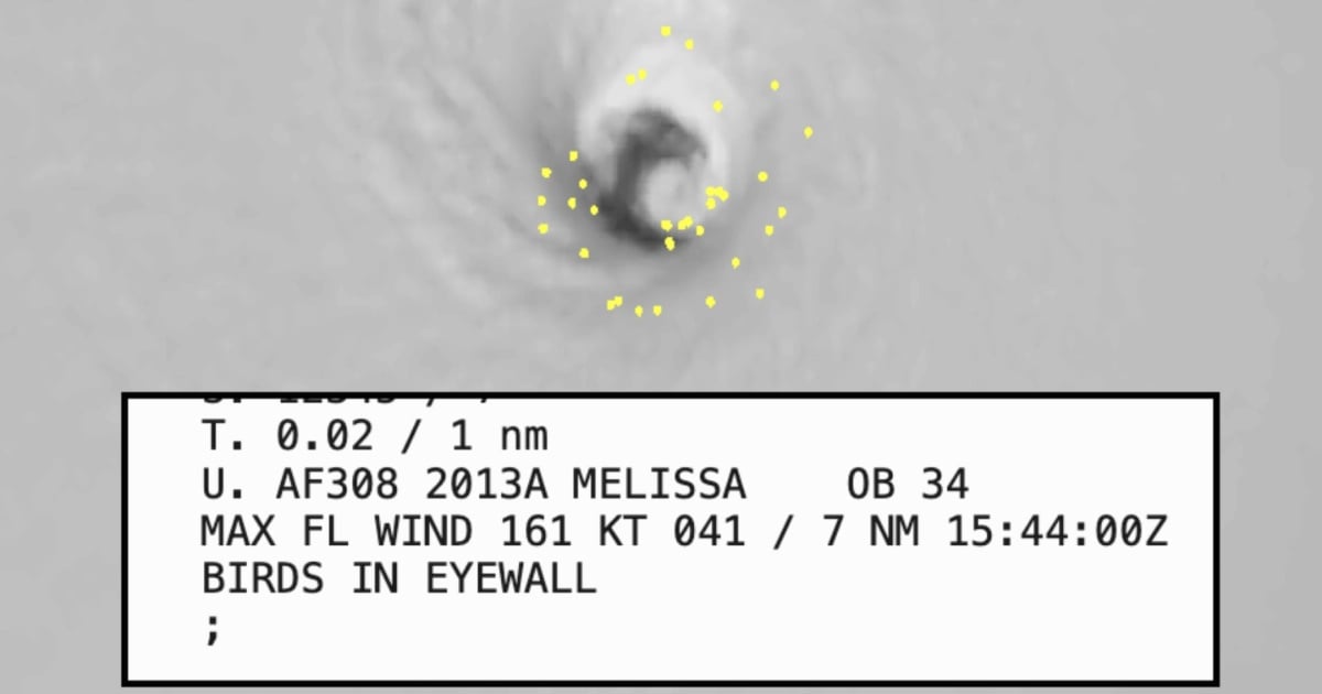
On Monday, a U.S. Air Force reconnaissance plane made a startling observation: birds caught within the eye of Hurricane Melissa. This phenomenon underscores the storm's fierce intensity, which has escalated to a Category 5 with winds clocking in at 174 mph (280 km/h) and a central pressure of 906 mb.
Meteorologist Matthew Cappucci speculated that potentially tens of thousands of birds have been sucked into the eye, unable to escape the powerful inward-pulling winds. "Most of these birds are trapped," he noted on social media platform X. "They often cannot break free until the storm weakens, unless they find an island to take refuge on."
Recalling historical events, Cappucci mentioned the 1938 hurricane that swept tropical birds to New England. Over open waters, birds face a dire situation with no land to alight on. "Some fall from the sky, succumbing to exhaustion," he explained.
The National Hurricane Center has labeled Melissa a "potentially catastrophic" system, following a rapid intensification over the Caribbean during the weekend. Satellite imagery reveals a nearly perfect formation: a compact ring of intense storms encircling a 12-mile (19 km) wide eye, with cloud tops dipping below –112 °F (–80 °C) and a pronounced outflow channel to the north, characteristics typical of the most severe cyclones.
The hurricane's conditions were so extreme that a dropsonde released by hurricane hunters recorded a gust of 241 mph (388 km/h) at an altitude of 709 feet, one of the highest ever documented in such a storm.
The NOAA’s N42RF “Kermit” aircraft had to abort its mission after penetrating the eye twice on Monday morning due to severe turbulence encountered in the southwestern eyewall. This marks only the fifth instance where NOAA hurricane hunters have been forced to terminate a flight due to such conditions, previously seen in hurricanes Allen (1980), Emily (1987), Hugo (1989), and Felix (2007).
The flight report also noted the presence of birds swirling within the eye, a rare occurrence when creatures are caught in the storm's circulation, confined to the relative calm of the central zone.
This event unfolds with Melissa ranking among the most extreme hurricanes in the basin. The 906 mb pressure, recorded late in the season, is cited as the lowest observed in the Atlantic at this time of year, positioning Melissa as the strongest storm of 2025.
Jamaica faces a particularly precarious situation, with hurricane warnings remaining in effect as the storm could make landfall by Tuesday morning. Authorities anticipate devastating winds, flash floods, and landslides. The storm's slow movement has caused rainbands to linger over the nation and the surrounding region, prompting officials to urge caution, complete preparations, and stay informed with official updates.
Understanding the Impact of Hurricane Melissa
How are birds affected by hurricanes like Melissa?
Birds can become trapped within the eye of the hurricane, unable to escape due to the strong winds. Without land, they may eventually fall from exhaustion.
What makes Hurricane Melissa considered "potentially catastrophic"?
Melissa's classification as "potentially catastrophic" stems from its rapid intensification, high wind speeds, and low central pressure, indicating extreme destructive potential.
Why did the NOAA's “Kermit” aircraft abort its mission?
The “Kermit” aircraft aborted its mission due to extreme turbulence encountered in the hurricane's southwestern eyewall, marking only the fifth occurrence of such an event.