The Cuban Institute of Meteorology (INSMET) has released its fifth Tropical Cyclone Alert this Thursday in response to Tropical Storm Melissa, currently over the waters of the Caribbean Sea.
In their latest update, issued at 6:00 a.m. on October 23, the Forecast Center warns of the potential intensification of the storm, which is situated in a highly active area conducive to its development.
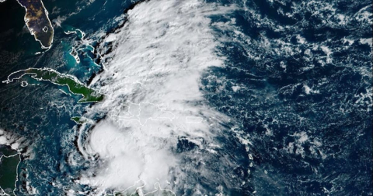
At 6:00 a.m., Melissa's center was located at 15.0 degrees latitude North and 75.0 degrees longitude West, placing it approximately 230 miles southeast of Kingston, Jamaica. The system is moving west-northwest at a slow pace of just 4 mph.
Melissa is currently maintaining maximum sustained winds of 53 mph, with stronger gusts, and a central pressure of 1002 hPa. These metrics suggest that, although still a tropical storm, conditions could soon change.
Track and Intensification Outlook
Over the next 24 hours, it is expected that the storm will keep its current speed but gradually shift its path towards the northwest and then north, moving further into the central Caribbean Sea, south of the Greater Antilles.
The Institute cautions that "oceanic and atmospheric conditions will be favorable for its gradual intensification," requiring close monitoring of the system.
While Melissa is not currently near Cuban territory or other populated areas of the western Caribbean, its position, slow movement, and the time of year are causing concern among meteorologists.
The official report states that it "poses a potential danger for our geographical area." The storm's continued presence over the warm waters of the Caribbean could fuel its development and strengthen its winds, heightening the risk for nearby countries, including Cuba.
The Forecast Center of the Meteorology Institute is maintaining continuous surveillance of the storm and has announced that the next alert will be issued at 6:00 p.m. this Thursday, or earlier if necessary.
Meteorological authorities emphasize the importance of staying informed about the evolution of this phenomenon, which could become a direct threat.
Expert Warning: Melissa Could Threaten Cuba
In recent hours, esteemed meteorologist José Rubiera described the forecast as "very challenging" due to the uncertainty regarding the storm's path.
He noted that while Melissa appears organized with its cloud cover, its center is displaced by strong vertical wind shear, preventing its full development. As a result, the system remains nearly stationary without a defined direction.
The meteorologist indicated that a significant change could occur by Sunday: if the wind shear decreases, Melissa could vertically align, rapidly strengthen, and potentially become a hurricane, possibly of great intensity, given the high heat content of the western Caribbean Sea.
In that scenario, a new trough from the southwestern United States could "capture" Melissa and redirect its movement to the north or northeast, posing a danger to Cuba.
Rubiera urged maximum attention and vigilance, particularly from Sunday to Monday, advising against alarmism but reminding that the country must be prepared for a potential threat.
The National Hurricane Center (NHC) has confirmed that Melissa continues its slow movement and could become a hurricane within the next 48 hours.
FAQs about Tropical Storm Melissa
What is the current status of Tropical Storm Melissa?
Tropical Storm Melissa is currently located in the Caribbean Sea with maximum sustained winds of 53 mph and is expected to potentially intensify.
Is Melissa expected to impact Cuba directly?
While Melissa is not currently near Cuba, its path and potential intensification pose a possible threat, warranting close monitoring.
What are the expected developments for Melissa?
Melissa is expected to gradually change its path and potentially intensify due to favorable oceanic and atmospheric conditions.