Tropical Storm Melissa is undergoing reorganization over the warm waters of the central Caribbean. The National Hurricane Center (NHC) has issued warnings about potential heavy rains, flooding, and landslides affecting several islands in the region, particularly focusing on Haiti, the Dominican Republic, and Jamaica. While Cuba is not currently under any official alerts, the NHC has specifically advised the nation to closely monitor the storm's progress, as it may soon escalate to hurricane status.
Melissa's Path Towards the Western Caribbean
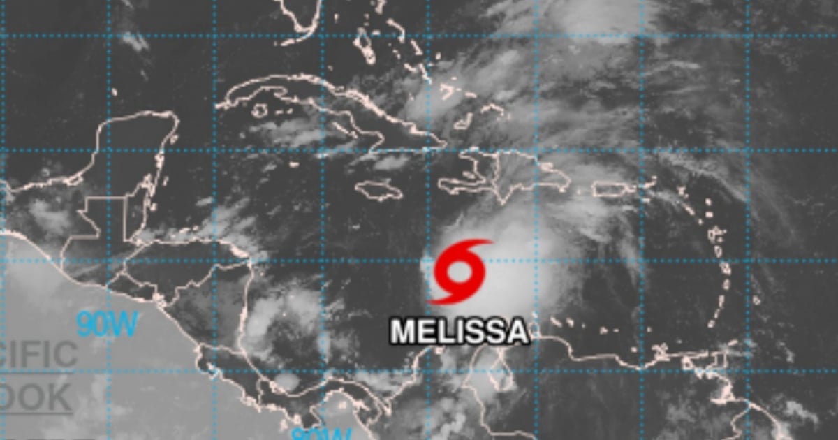
As per the 5:00 AM EDT bulletin on Wednesday, Melissa was positioned near latitude 14.3 N and longitude 73.5 W, approximately 495 km south-southwest of Port-au-Prince, Haiti. The storm exhibited sustained winds of 85 km/h and was moving west-northwest at a speed of 11 km/h. Current atmospheric and oceanic conditions suggest a gradual strengthening, with a high probability of Melissa becoming a hurricane by Thursday or Friday as it approaches southwestern Haiti and Jamaica.
Hurricane and Tropical Storm Alerts Issued
Meteorological authorities have issued a hurricane alert for Haiti's southwestern peninsula, from the Dominican border to Port-au-Prince, and a tropical storm alert for all of Jamaica. This indicates that within 48 hours, destructive winds, torrential rains, and dangerous storm surges could occur. Although Cuba is not under direct threat, the NHC emphasized that "interests in other parts of Haiti, the Dominican Republic, and Cuba should monitor Melissa's progress," suggesting potential indirect impacts, especially in eastern regions of Cuba.
Potential Impacts on Cuba
Current forecasts do not place Cuba in Melissa's direct path. However, secondary effects, such as moderate rains and coastal surges, could be experienced, particularly in the eastern parts of the island. Rainfall accumulations of 2 to 7 cm are expected in eastern Cuba, along with possible rip currents over the next 48 hours due to the storm's oceanic activity.
Latest trajectory models, often referred to as "spaghetti models," and intensity predictions indicate that Melissa is unlikely to exit the Caribbean swiftly. This delay increases the risk for Cuban territory as the system consolidates and moves further west. Meteorologist Raydel Ruisánchez warned on Facebook that "Melissa will remain over the very warm waters of the Caribbean Sea for the rest of the week, with upper atmospheric winds becoming more favorable for significant intensification south of Cuba."
Flooding and Landslides: A Major Concern
The primary danger from Melissa is not just the wind but the substantial rainfall it carries. The NHC predicts southern Haiti, the southern Dominican Republic, and eastern Jamaica could receive between 12 and 25 centimeters of rain by Saturday, with local areas potentially seeing even more. These heavy rains, especially on mountainous and already saturated terrain, could lead to flash floods, river overflows, and catastrophic landslides.
Even in regions further from the storm's center, such as northern Haiti, northern Dominican Republic, and western Jamaica, rainfall amounts could range from 5 to 10 cm. Aruba, Puerto Rico, and eastern Cuba anticipate rainfall between 2 and 7 cm. The NHC report warns that "the combination of torrential rains and mountainous terrain is a recipe for dangerous flash floods and landslides."
Two Possible Trajectories with Regional Risks
Current models suggest two probable paths for Melissa:
Scenario A (more likely): The storm turns north towards Hispaniola (Haiti and Dominican Republic), potentially reaching hurricane status by Saturday. This path would also impact Jamaica and increase the risk for Cuba's coasts if the storm takes a broader turn.
Scenario B (less likely): Melissa continues westward, approaching Central America (Nicaragua or Honduras) by mid-next week. In this case, the northern Caribbean would experience less intense rain but over a prolonged period, and Cuba might find itself in the storm's path if the turn is delayed.
Both scenarios pose regional challenges, with high uncertainty due to the system's slow movement and changing atmospheric conditions. For the United States, while the current risk of a direct hit remains low, Florida and the East Coast might face strong waves and rip currents next week. Past late-season storms, like Hurricane Nicole in November 2022 and Hurricane Zeta in October 2020, have shown that such cyclones can be equally hazardous.
Frequently Asked Questions about Tropical Storm Melissa
What areas are under alert due to Tropical Storm Melissa?
Hurricane alerts have been issued for the southwestern peninsula of Haiti, and tropical storm alerts are in place for all of Jamaica.
Is Cuba at risk from Tropical Storm Melissa?
Cuba is not in Melissa's direct path, but could experience indirect effects such as moderate rains and coastal surges, especially in the eastern parts of the island.
What is the biggest threat from Tropical Storm Melissa?
The most significant threat from Melissa is the heavy rainfall, which could lead to flash flooding and landslides, particularly in mountainous and saturated areas.
Could Melissa impact the United States?
While a direct impact on the U.S. is currently unlikely, Florida and the East Coast might experience strong waves and rip currents next week.