A broad area of low pressure currently forming in the central Caribbean Sea is on the verge of developing into a tropical storm, potentially impacting several Caribbean islands, including Cuba. The latest update from the National Hurricane Center (NHC), released at 8:00 a.m. Eastern Time, indicates that the tropical system known as AL98 is expected to evolve into Tropical Storm Melisa by Tuesday, marking the thirteenth storm of the current hurricane season.
Meteorological models suggest that Cuba is within the potential path of this system, raising the likelihood of heavy rains, strong winds, and flooding in the coming days. The Canadian model (GEPS) outlines various scenarios, one of which includes a direct impact on the island with a minimum pressure estimated at 982 millibars, suggesting a strong tropical storm or possibly even a hurricane.
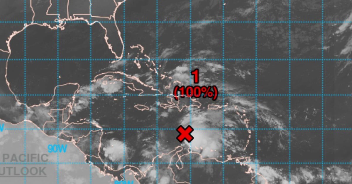
Recent satellite, radar, and surface observations reveal that the system already has a well-defined center, a crucial characteristic for the transition from low pressure to a tropical storm. Additionally, it is generating sustained winds of up to 45 miles per hour (72 km/h), exceeding the minimum threshold for classification as a tropical storm (39 mph or 63 km/h).
Potential Impact on Caribbean Nations
The storm is currently slowing down, which could allow for further intensification over warm waters and favorable atmospheric conditions. This slow movement also increases the risk of prolonged rainfall over island and coastal regions.
The NHC advises residents in Puerto Rico, Hispaniola (Dominican Republic and Haiti), Jamaica, and Cuba to stay informed and closely monitor the system's progress. Although its exact path and development remain uncertain, Eastern Cuba could be directly in the storm's trajectory in the coming days, as suggested by one of the latest models.
The potential for heavy rainfall, strong winds, and high surf may result in hazardous conditions starting later this week. Meteorological and civil protection authorities must evaluate possible preventive alerts in the coming hours.
Insights from José Rubiera
Renowned Cuban meteorologist José Rubiera has noted that this week could be one of the most interesting in the current hurricane season. Rubiera discussed the various models, describing the forecast as "challenging" due to inconsistencies between models, though both are justified. He emphasized the need for vigilance in the coming hours as the situation develops.
Reconnaissance Missions and Marine Forecasts
The U.S. Air Force Hurricane Hunters plan to conduct a reconnaissance mission to directly investigate the system on Tuesday. These flights are crucial for confirming the cyclone's internal structure and improving forecast models. Additionally, the NHC recommends consulting the National Weather Service's high seas forecasts for more details, especially regarding gale warnings and adverse navigation conditions.
High Likelihood of Cyclonic Development
The bulletin highlights a 100% probability of tropical storm formation within the next 48 hours. The situation poses an imminent cyclonic risk, with potential for increased intensity if atmospheric conditions are favorable.
What to Expect in the Coming Hours
The development of this system will be key in determining the level of threat to Cuba. Although it is still early to ascertain whether it will reach hurricane status, preliminary models point to a scenario that could affect the eastern region of the country with torrential rains, power outages, and urban and rural flooding. Upcoming updates from the NHC will be critical in tracking the system's strengthening and projecting its path.
If confirmed as a tropical storm, it will be given an official name from the corresponding list for the 2025 season.
FAQs on the Developing Tropical Storm in the Caribbean
What is the current status of the system in the Caribbean?
The system, identified as AL98, is expected to become Tropical Storm Melisa and poses a threat to several Caribbean islands, including Cuba.
How might Cuba be affected by this tropical system?
Cuba could experience heavy rains, strong winds, and flooding, particularly in the eastern region, if the storm follows one of the projected paths.
What actions are being taken to monitor the storm?
The U.S. Air Force Hurricane Hunters are conducting reconnaissance missions, and the NHC continues to issue updates and forecasts to track the storm's development.