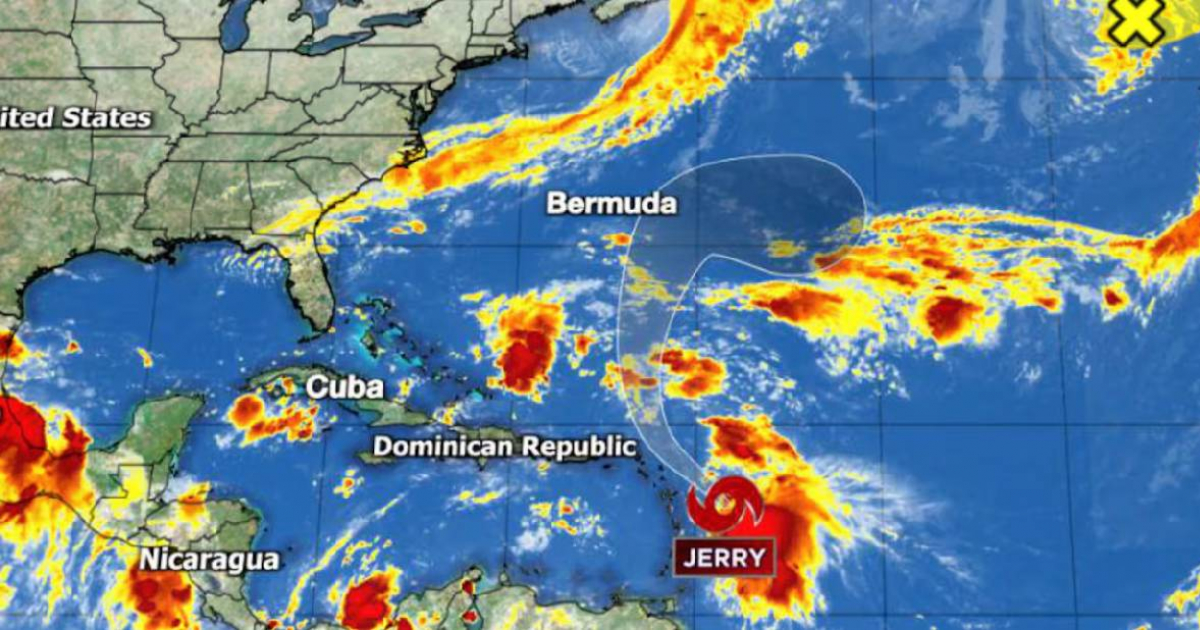
Despite its seemingly disorganized appearance, Tropical Storm Jerry has intensified and is on the brink of reaching hurricane status as its center moves northward toward the Leeward Islands, located at the northeastern edge of the Caribbean, this Thursday. According to meteorological models, the strongest winds are concentrated east of the system's center, which means that sustained tropical storm conditions (winds exceeding 39 mph) are not anticipated in the southwest region, encompassing most of the islands.
However, the National Hurricane Center cautioned that Jerry's passage won't be without consequences. Its southeastern tail, laden with moisture and gusts, is expected to bring adverse conditions from tonight through Saturday to areas including Antigua and Barbuda, Saint Martin, Saint Kitts, Nevis, Montserrat, and Guadeloupe, all under a tropical storm watch due to winds potentially surpassing 39 mph.
Additionally, the trailing rainbands associated with the system could lead to significant water accumulation and flash flooding, particularly in mountainous terrains across the Leeward Islands and the Virgin Islands, the weather report emphasized.
An anticipated cold front, set to cross Florida this weekend, will redirect Jerry out to sea. Forecasts indicate that the system poses no threat to the United States or Bermuda, which is still recovering from the recent impact of Imelda.
Instead, meteorological focus shifts to a developing non-tropical coastal storm off the Carolinas, which might evolve into a quasi-nor’easter between Saturday and Monday, impacting areas from the Carolinas to the northeastern United States with winds over 43 mph and heavy rainfall.
Charleston and other Atlantic coastal areas have already begun experiencing coastal flooding, which is expected to worsen with Friday morning's high tide. Several cycles of moderate to severe flooding are anticipated over the weekend.
While the coastal system is non-tropical in origin, there is a possibility it could develop into a subtropical cyclone early next week. If this occurs, it would be named Karen, but such a change would not alter the adverse conditions expected along the U.S. east coast.
Meanwhile, a non-tropical low pressure system, designated as Invest 96L, is creating storm conditions northwest of the Azores. This system, situated at an atypical latitude for tropical cyclones, is attempting to generate convection near its center but has only a narrow window for development. Should it briefly become a tropical or subtropical cyclone, it would be an unusual event with no impact on land and short-lived.
Tropical Weather Concerns and Developments
What areas are under threat from Tropical Storm Jerry?
Tropical Storm Jerry poses a threat to locations such as Antigua and Barbuda, Saint Martin, Saint Kitts, Nevis, Montserrat, and Guadeloupe, where adverse weather conditions and strong winds are expected.
Is the United States at risk from Jerry?
No, current forecasts indicate that Tropical Storm Jerry does not pose a danger to the United States, as it is expected to be redirected out to sea by an approaching cold front.
Could the coastal storm near the Carolinas become a subtropical cyclone?
Yes, there is a possibility that the non-tropical coastal storm could develop into a subtropical cyclone, potentially being named Karen, although this would not change the expected adverse conditions along the U.S. east coast.