Imelda, now a tropical storm as of this past Sunday, is making its way northward, bringing heavy rain to the Bahamas and eastern provinces of Cuba, with potential effects expected on the eastern United States coast in the coming days, according to the National Hurricane Center (NHC). Although Imelda's center is not predicted to make landfall in the U.S., its impacts will still be felt along the southeastern coastal areas.
The latest bulletin from the NHC forecasts rainfall amounts ranging from 1 to 2 inches (25 to 50 mm) from northeastern Florida to North Carolina, with possible peaks reaching up to 4 inches (100 mm) in certain locales. This precipitation could lead to minor urban flooding and isolated stream or secondary river overflow, particularly in areas with saturated soils or poor infrastructure.
As of 5:00 a.m. Eastern Time on Monday, September 29, the system was approximately 60 miles (100 km) south of Great Abaco Island and around 295 miles (475 km) southeast of Cape Canaveral, Florida. Maximum sustained winds are recorded at 45 miles per hour (75 km/h), with a northward movement at a speed of 8 mph (13 km/h).
Potential U.S. Coastline Impacts
Imelda is producing rainfall accumulations between 2 and 4 inches (50 to 100 mm) in eastern Cuba, and up to 8 inches (200 mm) in the northwestern Bahamas through Tuesday, posing risks of urban flooding, sudden floods, and landslides in the elevated regions of eastern Cuba. The system is also expected to indirectly affect the U.S. mainland; the NHC predicts 1 to 2 inches (25 to 50 mm) of rain along the Carolinas' coast, with maximums reaching 4 inches (100 mm), potentially causing minor flooding and small river rises.
Strengthening into a Hurricane
There is a possibility that Imelda could intensify within the next 24 to 36 hours, potentially becoming a hurricane by Tuesday. This development could increase the storm's effects on southeastern U.S. coastal areas due to wave action, rip currents, and minor storm surges.
Projected Path: From Western Caribbean to the Atlantic
At 5:00 a.m. EDT Monday, Imelda's center was positioned at 25.5° North latitude and 77.1° West longitude. The forecast suggests the system will continue its northward path throughout the day, with a sharp turn towards the east-northeast on Tuesday, steering away from the southeastern United States and heading into the western Atlantic. However, the storm's extensive reach—with tropical-storm-force winds extending up to 175 miles (280 km) from its center—means its effects will be felt beyond its central path, notably in the Bahamas, the Atlantic coast of the Caribbean, and the southeastern U.S.
Current Warnings and Recent Changes
The Bahamas government has lifted tropical storm warnings for central and some northwestern areas, including New Providence, the Berry Islands, and Andros Island. However, a tropical storm warning remains in effect for Eleuthera, the Abaco Islands, Grand Bahama Island, and surrounding northwestern keys. A tropical storm warning signifies that hazardous conditions are expected on land within the next 12 hours, including strong wind gusts, heavy rain, and rising sea levels. Rainfall accumulations in the northwestern archipelago could range from 4 to 8 inches (100 to 200 mm) through Tuesday, posing significant risks of urban and flash flooding, especially in low-lying areas lacking proper drainage systems.
Coastal Flooding and Dangerous Surf
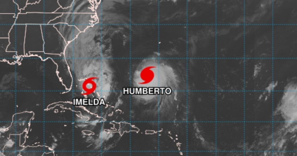
Imelda's expansive impact includes high surf and hazardous rip currents. The NHC warns that both Imelda and Hurricane Humberto, also active in the Atlantic, are generating swells affecting the Bahamas and will extend along the U.S. East Coast in the coming days. These swells could lead to:
- Potentially deadly rip currents, posing significant risks to swimmers, surfers, and small watercraft.
- Substantial wave action, complicating maritime conditions from Florida to the Carolinas.
Additionally, minor coastal flooding is possible in areas where onshore winds prevail. Vulnerable zones for flooding include the coast between:
- The Volusia/Brevard county line (Florida).
- The South Santee River (South Carolina).
Here, water levels could rise 1 to 2 feet (30 to 60 cm) above ground, especially during high tide cycles.
Bermuda Also on Alert
As Imelda shifts east-northeast, Bermuda might experience indirect effects from the system. From Wednesday to Thursday, forecasts predict rainfall between 50 and 100 mm and strong surf, though without a direct impact from the storm's center.
An Active Hurricane Season Far from Over
Imelda is part of an especially active 2025 Atlantic hurricane season, as predicted by the NOAA in May. Several named storms have formed so far, including Andrea in June; Gabrielle, a Category 4 hurricane that impacted eastern Bermuda, and Humberto, currently active in the central tropical Atlantic. The season officially spans from June 1 to November 30, but current atmospheric and oceanic conditions—warmer sea surface temperatures and reduced wind shear—continue to support above-average activity.
In its August update, the NOAA projected:
- 13 to 18 named storms (winds greater than 39 mph / 63 km/h)
- 5 to 9 hurricanes (winds >74 mph / 119 km/h)
- 2 to 5 major hurricanes (Category 3 or higher, >111 mph / 179 km/h)
If Imelda continues to strengthen, it could become the next system to reach hurricane status.
Recommendations: Stay Vigilant and Cautious
Although Imelda is not on a direct path to U.S. landfall, its effects are already being felt in the Caribbean and along the Atlantic coast. The National Hurricane Center advises residents and visitors in affected areas to:
- Keep informed through official bulletins from the NHC and local meteorological services.
- Avoid entering the ocean in areas experiencing strong surf or rip current risks.
- Pay attention to potential flood alerts in urban or runoff-prone regions.
- Do not underestimate the indirect risks posed by storms offshore.
Imelda's evolution over the next 24 to 48 hours will be crucial in determining its final category and the impact level on the region.
Frequently Asked Questions About Imelda and Hurricane Season
What is the current status of Tropical Storm Imelda?
Imelda is currently a tropical storm, moving northward with potential to become a hurricane within the next 24 to 36 hours.
Which areas are most at risk from Imelda?
The Bahamas, eastern Cuba, and the southeastern U.S. coastline, including Florida to North Carolina, are expected to experience impacts from Imelda.
What precautions should residents in affected areas take?
Residents should monitor official NHC updates, avoid ocean activities during rough surf, and prepare for potential flooding in susceptible regions.
How does Imelda fit into the 2025 hurricane season?
Imelda is part of an active 2025 Atlantic hurricane season, with several named storms already, and could become a hurricane if it strengthens further.