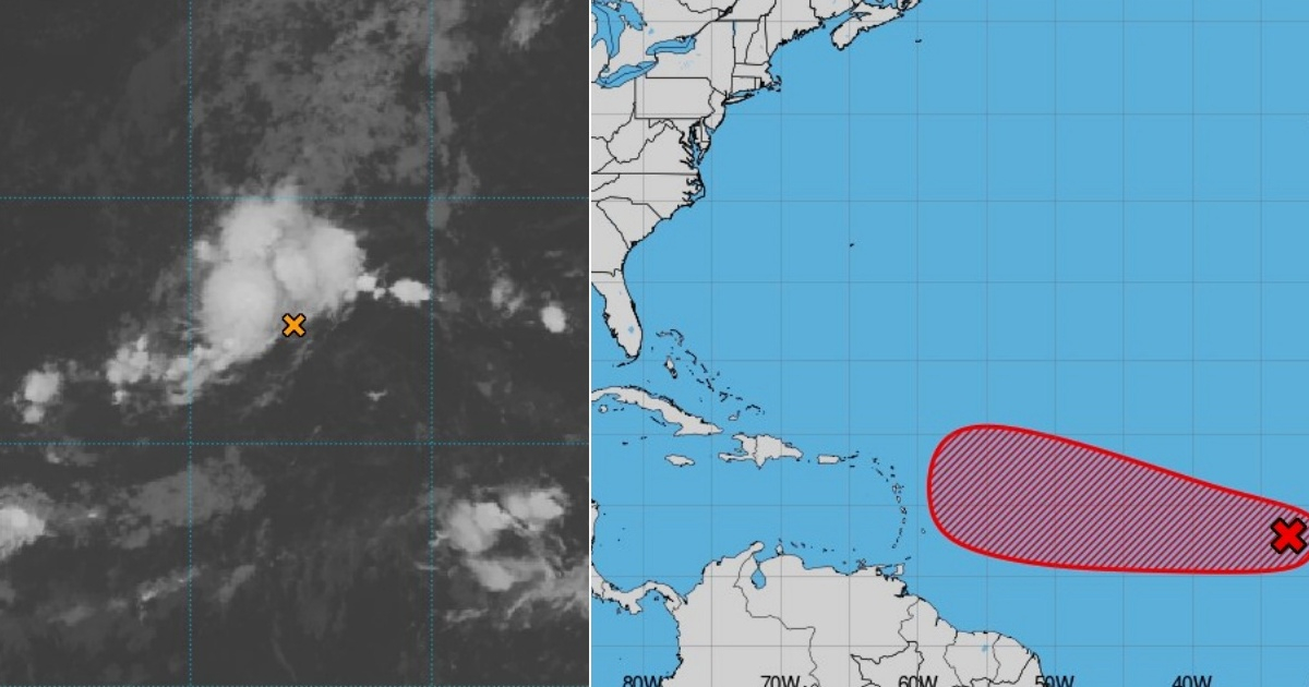
The National Hurricane Center (NHC) has raised the likelihood of a tropical wave currently moving slowly across the eastern Atlantic towards the Caribbean evolving into a depression. This system, which had previously exhibited sporadic signs of organization, is now showing more coherent development, creating a more conducive environment for it to become a tropical depression. The latest official report from the NHC indicates a 50% chance of cyclonic formation within the next 48 hours. Over the span of seven days, this probability increases to 80%, making it the most promising disturbance for development in the Atlantic basin at present.
According to the most recent update from the NHC, the tropical wave is situated several hundred miles west-southwest of the Cape Verde Islands. Satellite imagery reveals an uptick in rainfall and thunderstorms, suggesting that the atmospheric circulation associated with this phenomenon is becoming more robust. Experts caution that the conditions are favorable for the disturbance to continue strengthening. Factors such as warm ocean temperatures, low wind shear in high atmospheric levels, and regional moisture provide the necessary conditions for cyclonic development.
Short and Medium-Term Forecast
Meteorologists at the NHC predict that a tropical depression might form by the end of this week as the system slowly moves west-northwest at a rate of 5 to 10 miles per hour (8 to 16 km/h). Subsequently, it is expected to quicken its pace towards the west or west-northwest, potentially positioning it over the waters east of the Lesser Antilles by the middle of next week. This trajectory means that the Caribbean island chain should monitor its progress closely, as it might approach with greater organization and strength in the coming days.
This announcement is part of an already active hurricane season. The central and eastern tropical Atlantic are closely watched by specialists, as numerous cyclones originate there and can gain storm or hurricane strength before approaching the Caribbean and North America. Meteorologists emphasize that it is still too soon to determine the potential intensity of this system or if it will directly impact any Caribbean territory. Nevertheless, current conditions serve as a reminder of the need for constant vigilance and the importance of preparedness plans in the region.
The Atlantic hurricane season is currently at its most active phase. Historically, September has been a critical month for hurricanes impacting Cuba. Recently, Cuban meteorologist Christian Jesús Muñiz Carrillo pointed out that between 1950 and 2023, nine hurricanes made landfall on the island during September, including the powerful Ike (2008), Irma (2017), and Ian (2022). Irma holds the record as the only Category 5 hurricane to have struck Cuba with such intensity.
Tropical Wave Development and Impact
What are the current chances of the tropical wave developing into a depression?
The National Hurricane Center has reported a 50% chance of cyclonic development in the next 48 hours, with an 80% probability over the next seven days.
What conditions are favorable for the tropical wave's development?
Favorable conditions include warm ocean temperatures, low wind shear, and regional moisture, all contributing to the potential cyclonic development.
When is the tropical depression expected to form?
Meteorologists anticipate that a tropical depression could form by the end of this week, as the system continues its movement west-northwest.