A fresh tropical wave in the eastern Atlantic is drawing the focus of the National Hurricane Center (NHC) due to its potential for development in the upcoming days. Although currently an area of disorganized showers and thunderstorms, meteorologists warn that environmental conditions could become more conducive later this week, possibly leading to the formation of a tropical depression.
The system, moving west to west-northwest at approximately 20 mph (32 km/h), has a 50% chance of developing into a tropical cyclone over the next week, according to the latest NHC bulletin. Currently, the chance of formation in the next 48 hours is zero, but if the trend continues, it could approach the Leeward Islands—at the eastern edge of the Caribbean—by Friday. If it strengthens into a tropical storm, it would be named "Fernand," the next name on the 2025 cyclone season list.
Favorable Conditions for Development
Experts at the NHC emphasize that tropical waves like this can intensify quickly given certain conditions, such as warm ocean waters, low wind shear, and a moist atmosphere. This scenario is not unlikely, considering the Atlantic basin is currently in its peak cyclone formation period, encompassing August, September, and October. According to the NHC, “Environmental conditions appear conducive to the gradual development of this system.”
While the convective activity remains disorganized, if the system achieves a closed and persistent circulation, it could be classified as a tropical depression at any point over the weekend. These early formations can bring heavy rains, gusty winds, and storm surges even before officially becoming designated tropical cyclones, prompting authorities to closely monitor its evolution, particularly in the Lesser Antilles and eastern Caribbean.
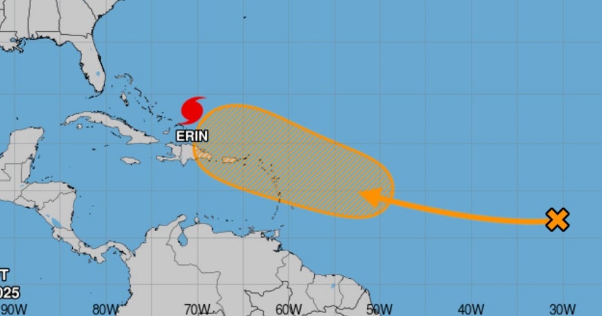
Erin Strengthens East of Bahamas, Creates Hazardous Conditions in Western Atlantic
Despite the center of Hurricane Erin continuing its path away from land, its intensity and size make it a system to watch carefully. In its 8:00 a.m. Eastern Time advisory this Monday, the NHC classified Erin as a Category 4 hurricane, with maximum sustained winds of 130 mph (215 km/h) and a central pressure of 933 mb, maintaining its status as a major and dangerous hurricane.
At that time, Erin's center was located approximately 190 km north-northeast of Grand Turk Island, moving northwest at about 20 km/h. It is expected to continue its path east of the Bahamas and then move between the U.S. East Coast and Bermuda by midweek. Tropical storm conditions are already being felt in the Turks and Caicos Islands and southeastern Bahamas, with parts of the central Bahamas under advisory.
Heavy rains of 2 to 6 inches are forecast in parts of Hispaniola, the Turks and Caicos, and southeastern Bahamas, which could cause flash flooding. The NHC also advises caution along the U.S. Southeast coast, where strong rip currents may occur in the coming days, even without direct impacts from the hurricane.
Hurricane Season: Increasing Activity
The official Atlantic hurricane season runs from June 1 to November 30, with its climatological peak estimated around September 10. During this period, the likelihood of cyclonic development rises significantly as key factors such as elevated ocean temperatures (above 79°F), favorable winds, and atmospheric moisture align.
Erin is the fifth named tropical cyclone of 2025 and the first to reach hurricane status. The previous ones—Andrea, Barry, Chantal, and Dexter—did not progress beyond tropical storm strength.
Understanding Tropical Wave Developments and Hurricane Erin
What factors contribute to the development of tropical waves?
Tropical waves can develop rapidly when warm ocean waters, low wind shear, and a moist atmosphere combine, providing favorable conditions for intensification.
What is the current status of Hurricane Erin?
Hurricane Erin is classified as a Category 4 hurricane with maximum sustained winds of 130 mph and is currently moving northwest of Grand Turk Island.
Why is the Atlantic hurricane season's peak around September?
The peak of the Atlantic hurricane season is around September due to the alignment of warm ocean temperatures, favorable wind patterns, and increased atmospheric moisture, which are conducive to cyclonic development.