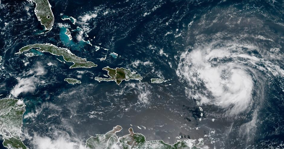
The United States' National Hurricane Center (NHC) announced on Friday that Erin has intensified to a Category 1 hurricane, marking it as the first of the 2025 Atlantic hurricane season. As per the 11:00 a.m. AST advisory, Erin is currently located at a latitude of 18.2°N and a longitude of 56.1°W, moving west-northwest at 18 mph (28 km/h), with sustained winds reaching 75 mph (120 km/h) and a central minimum pressure of 996 mb.
The NHC forecasts that the hurricane will travel near or to the north of the Leeward Islands on Saturday, continuing to grow stronger. It may even reach a high intensity—ranging from 3 to 5 on the Richter scale—between Saturday and Sunday. Although the projected path has shifted northward, distancing it from both Cuba and Florida's peninsula, warnings remain in place for other Caribbean areas.
Before Erin moves into open waters, the system could unleash heavy rainfall, flash floods, and landslides in southern and eastern Puerto Rico, as well as in the U.S. and British Virgin Islands. Tropical storm conditions could affect areas close to its center as it passes north of these islands.
Florida's meteorological center has described Erin as a powerful hurricane over the western Atlantic. They noted that "the Bahamas archipelago will shield our waters and beaches from most of the wave action linked to the storm." Nevertheless, the risk of waves and rip currents is expected to rise along the northeastern coast beaches next week, the agency warned on their platform.
Erin originated last Monday west of Cape Verde, leaving a tragic aftermath of at least seven fatalities, several missing persons, and significant material damage in the African archipelago. The NHC is not ruling out potential impacts next week in the Bahamas or Bermuda, depending on the storm's path.
This marks the fifth named system this season following Andrea, Barry, Chantal, and Dexter. The National Oceanic and Atmospheric Administration (NOAA) anticipates an "above-normal" season, predicting between 13 and 18 tropical storms and up to five major hurricanes from August through November.
Frequently Asked Questions about Hurricane Erin
Where is Hurricane Erin currently located?
As of the latest advisory, Hurricane Erin is positioned at 18.2°N latitude and 56.1°W longitude.
What is the projected path of Hurricane Erin?
The National Hurricane Center forecasts that Erin will pass near or to the north of the Leeward Islands and could potentially affect the Bahamas or Bermuda depending on its trajectory.
What are the expected impacts of Hurricane Erin?
Erin may cause heavy rain, flash floods, and landslides in Puerto Rico and the Virgin Islands, with tropical storm conditions likely near the center as it passes north of these islands.