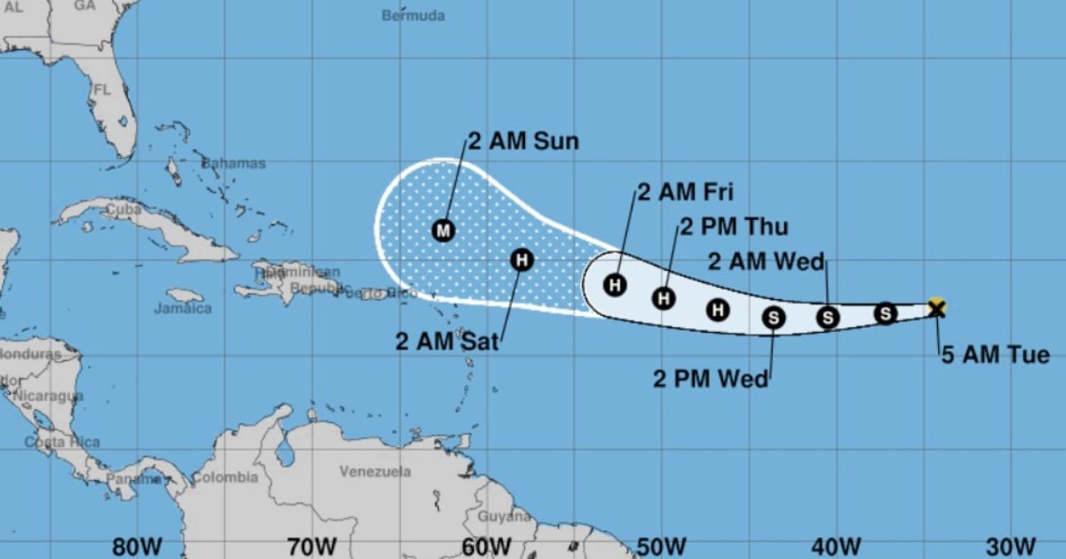
Formed on Monday over the eastern Atlantic, Tropical Storm Erin is anticipated to intensify in the coming days, potentially becoming the first major hurricane of the 2025 season. The latest update from the U.S. National Hurricane Center (NHC) highlights Erin's rapid development.
As of 5:00 a.m. local time, the NHC reported that Erin was centered near latitude 17.4°N and longitude 34.3°W, approximately 1,105 kilometers west of the Cape Verde Islands and 3,045 kilometers east of the northern Leeward Islands. The storm boasts maximum sustained winds of 45 mph (75 km/h) with stronger gusts, moving westward at a speed of 22 mph (35 km/h). The estimated central pressure is 1004 mb, and tropical storm-force winds extend up to 75 kilometers from the center. Currently, there are no coastal watches or warnings in effect.
Will Erin Transform into a Hurricane?
According to the NHC, Erin is expected to strengthen soon, continuing its westward advance with a gradual reduction in speed before slowly turning west-northwest. If favorable conditions persist, Erin could reach hurricane status by Tuesday night or Wednesday as it moves into the central tropical Atlantic.
Key Influences on Erin's Development
The evolution of Erin hinges on two primary factors:
- The Bermuda High: This expansive high-pressure area in the Atlantic plays a significant role in steering tropical cyclones, potentially guiding Erin towards the Caribbean or altering its path.
- Sea Surface Temperatures: The western Atlantic waters are currently warmer than average for this time of year, providing ample energy for Erin to strengthen.
Erin marks the fifth tropical storm since the start of the current hurricane season, with predecessors Andrea, Barry, Chantal, and Dexter failing to reach hurricane strength. If Erin intensifies as expected, it will confirm predictions of a more active season, driven by record ocean temperatures and favorable atmospheric conditions.
2025 Hurricane Season Outlook
The Atlantic hurricane season officially began on June 1 and runs through November 30. Meteorologists had warned that 2025 could see more intense and frequent cyclones. While Erin currently poses no immediate threat to populated areas, the NHC advises residents in Caribbean coastal areas, the Antilles, and the southeastern United States to stay informed via official updates, as the system’s final trajectory will depend on the atmospheric and oceanic conditions it encounters.
CNN cautioned that "it's still too early to determine Erin's potential impact on the Caribbean," noting that no advisories or warnings have been issued by U.S. authorities at this time.
Monitoring Erin from Cuba
The Cuban Institute of Meteorology (INSMET) issued its initial tropical storm advisory on Monday following Erin's formation. INSMET forecasts that Erin will continue on a similar path, gaining organization and strength over the open waters of the eastern Atlantic. Although the system currently poses no threat to Cuba, given its location and the time of year, the Forecast Center is closely monitoring its progress.
Frequently Asked Questions about Tropical Storm Erin
How soon is Erin expected to become a hurricane?
Erin is projected to reach hurricane status by Tuesday night or Wednesday if conditions remain favorable.
What factors affect Erin's development?
The Bermuda High's position and the warmer-than-average sea surface temperatures in the western Atlantic are key factors influencing Erin's development.
Is Erin a threat to populated areas?
Currently, Erin poses no immediate threat to populated areas, but residents in the Caribbean and southeastern U.S. should monitor official updates.