Isaac forecast: Storm could hit as hurricane near Pensacola, Fla.
- Submitted by: lena campos
- Environment
- 08 / 25 / 2012
But landfall wouldn't be until next Wednesday, so there's still considerable uncertainty about the projection. Tropical storm Isaac could affect Tampa before then, but that's still uncertain, too.
Waves break on the shore, as the Caribbean Sea churns up by Tropical Storm Isaac's passing to the south, in Santo Domingo, August 24. Tropical Storm Isaac passed the Dominican Republic and headed toward Haiti on Friday, rumbling slowly west across the Caribbean after unleashing heavy rain on parts of Puerto Rico.
Tropical storm Isaac is regaining strength as it heads toward the Dominican Republic, Haiti, and Cuba, according to forecasters at the National Hurricane Center in Miami.
But the tropical cyclone is not expected to reach hurricane strength until it's well up into the eastern Gulf of Mexico, off the west coast of Florida, forecasters say.
By Tuesday, during the Republican National Convention, the latest track estimate puts the center of Isaac some 217 miles west of Tampa, although the city still falls into the broad region covered by the error for track forecasts four days out. And it's unclear at this stage how far from the storm's center tropical-storm-force winds will extend.
QUIZ: Hurricane prep – are you smarter than a storm tracker?
In the meantime, if Isaac's track and intensity through the weekend hold close to the projections as of 11 a.m., Eastern time, on Friday, that could be a bit of good news for the western Dominican Republic and Haiti. On Thursday, forecasters were expecting the storm to reach hurricane strength just before making landfall across the southern tip of Hispaniola, the island that the two countries share.
Even so, Isaac is loaded with moisture and is still expected to dump as much as 20 inches of rain in some locations on the island. The storm is expansive enough to bring two to four inches of rain to Puerto Rico, the US Virgin Islands, and the southern Bahamas – all of which are under tropical-storm warnings.
The Cuban government also has posted tropical-storm warnings for the eastern two-thirds of the island, where Isaac could bring up to 10 inches of rain to some areas.
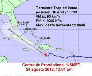
The latest advisory from the National Hurricane Center puts a poorly organized center for Isaac 163 miles south of Santo Domingo. The storm currently is posting maximum sustained winds of 45 miles an hour and is churning along its path at about 15 miles an hour.
Current projections have Isaac making landfall as a hurricane about 15 miles west of Pensacola on Wednesday morning, but this is a lead time where track forecasts are at their largest. The region of landfall uncertainty stretches from southeastern Louisiana through the center of northern Florida.
Once Isaac reaches terra firma, some forecast models suggest Isaac could curve to the northeast, where it would bring some badly needed rain to Alabama, Georgia, and South Carolina. Roughly half of Georgia is experiencing severe to exceptional long-term drought.
Meanwhile, tropical storm Joyce, which attained that standing Thursday in the central Atlantic, is now only a memory. Joyce encountered two features that spell doom for tropical cyclones: a broad area of dry air and changes in wind speed or direction with height, known as shear.
Both sapped what little starch Joyce had accumulated. The storm has been demoted to a garden-variety low-pressure system with showers and thunderstorms, and forecasters give it little or no chance of reorganizing. Indeed, it could dissipate as a low-pressure system at any time, forecasters say.
The impact: a bit of grumpy weather over Bermuda Monday and Tuesday.
Source: csmonitor.com
Comments